
It is difficult to accept as one this world of ghetto, criminal wars, urban violence, and inner erosion that coexists with bioengineering, genetic engineering, the pill, distant sensors, cyborgs, and an ever-increasing communications network.
—György Kepes, founder of the Center for Advanced Visual Studies at MIT, in Arts of the Environment, 19721
“I spent two years, thousands of hours in a dark room, navigating massive amounts of our country.”2
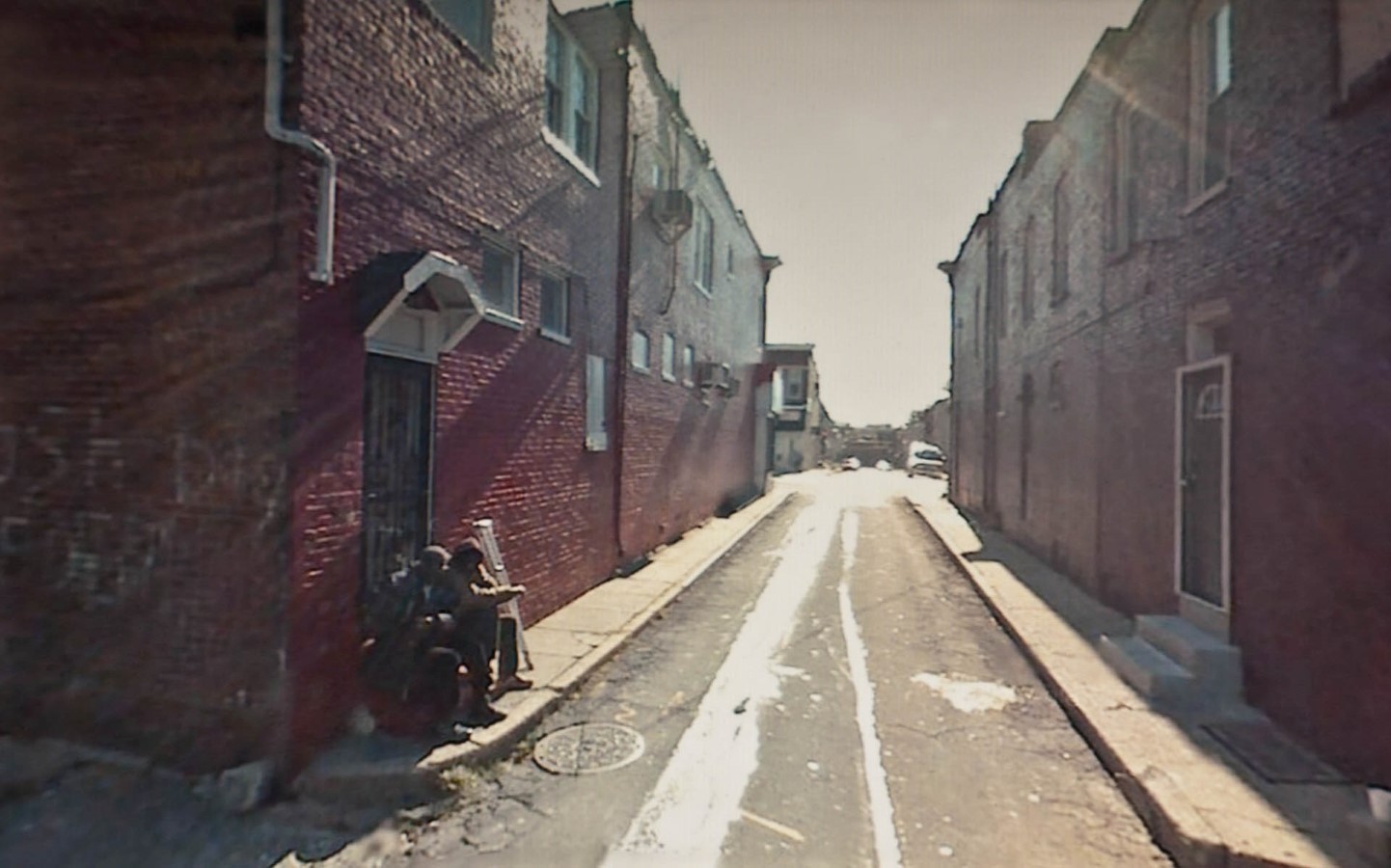
In April 2012, Doug Rickard stood onstage at the Annenberg Space for Photography, nestled within the corporate office parks of Los Angeles’s Century City, flipping through images of American urban poverty. 3 Despite a packed and attentive audience, Rickard seemed to be alone with his images. He showed men crouched in a Baltimore alleyway at twilight; a child-sized plastic car flipped over outside of a tract house in Arkansas; a man in tattered pants walking through Memphis, the letters RIP graffitied on the wall behind him.
While written to be empathetic toward poverty’s visual abjection, the talk quickly devolved into the parlance of the internet, from which this photographic project was born. In one particularly hard-to-watch sequence, Rickard embodied the intrepid gamer more so than the “fine artist,” emoting rawly, “I’m comin’ up behind him,” as the white photographer showed an image he had taken of a group of young Black men walking through a cemetery in New Orleans. That Rickard employed the language of watching, stalking, and ownership-via-camera should come as no surprise given the tool he used to drive, virtually, across the country: Google Street View.
The works featured in this talk comprise Rickard’s best-known project, A New American Picture. In the series, the artist selected scenes captured by Street View cameras of the poorest neighborhoods in the United States. Rickard then photographed his screen in a Levinian gesture of appropriation, his artistic intervention constituted by the act of recontextualizing digitally hosted scenes of destitution within physical spaces of aesthetic and material abundance: Annenberg, but also MoMA and Yossi Milo, the High Line–abutting Chelsea gallery that represents him. Because A New American Picture reproduces the earliest images taken on Google Street View, the photographs are low-resolution representations of street life, not Google’s more recent high-definition images, which, of course, still cannot replicate the real thing. These are fuzzy approximations of America’s poorest neighborhoods, whose residents are disfigured by the blur of deidentification.
In spite of, or perhaps because of, its voyeurism, A New American Picture resonated with viewers when it was released in the wake of the 2008 financial crisis. The project acted as a popular chronicle of the economic devastation wrought in those years—and much earlier—alongside the inverse explosion of tech capital. MoMA mounted selections from the series in its New Photography 2011 show, catapulting Rickard to more widespread visibility.4 Critics, in turn, persistently compared his work born of the Great Recession to the social documentary photography commissioned by the federal government during the Great Depression. As Geoff Dyer wrote in 2012, A New American Picture “contains obvious echoes of photographs made by [Walker] Evans under the auspices of the Farm Security Administration in the 1930s.”5 Writing in 2013, Teju Cole took stock of popular interest in technologically mediated urban images, as art or as data. “A New American Picture,” he wrote, “is a look at the collapse of certain cities: Detroit, Memphis, Oakland. The gaunt sun-stunned figures in these streets inhabit noonday nightmares, captured both by Google’s car-mounted camera and by the brutal reality of American capitalism.”6
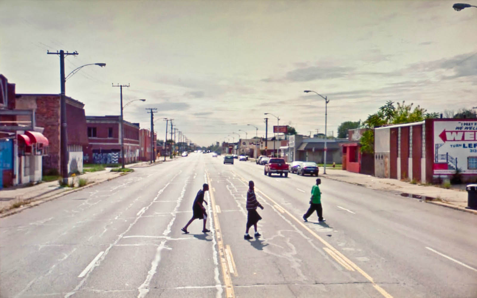
Writing from the belly of the crisis, Cole reminds readers that sleek techno-capitalist tools for seeing the world and the urban disinvestment they so often represent are strange bedfellows. This tension between imaging and living, between innovation and dispossession, is precisely what makes Rickard’s work resonant. One need look no further than Rickard’s #82.948842, Detroit, MI. 2009 to see the visual consonance between an imaging technology that degrades its subjects and the physical degradation of those subjects’ lived environments. In the image, three people walk across the city’s MLK Boulevard, five lanes of traffic between them and the other side of the road, their bodies flattened and stretched by Google’s camera like Giacometti sculptures. Google has made the figures unidentifiable, suppressing their personhood in a gesture toward privacy, while planned disinvestment has made this place inhospitable to the human body.
Because these months of living at home have pushed many into a Rickard-like posture, finding escape only in digital distraction, his project’s politics deserve reconsideration—especially if this particular mediated mode of urban interaction is to be with us for much longer. In the early days of lockdown, for example, Reif Larsen cheerily explained to readers of the New York Times travel section “How to See the World When You’re Stuck at Home.”7 Larsen suggests that readers follow his lead, replacing a canceled family vacation to Charleston, South Carolina, with Street View walks down the city’s manicured colonial streets. (When I mention my work on Street View to strangers, this is usually their reaction—that they too are in awe of the ability to “travel” to scenic locales from the comfort of home.)
But what of Rickard’s reverse inclination to see the country’s most disinvested neighborhoods through virtual travel? From where does the intimate—and, indeed, causal—relationship between infrastructural dereliction and the tools of techno-utopia arise? Why might it be more compelling for an elite, often white audience to hobbyistically surveil Watts, as Rickard does, than to delight in the attractions of Historic Downtown Charleston, as Larsen suggests? If such tendencies emerge in user behavior and artistic projects like A New American Picture, it is because a hollow empathy—a central pillar of neoliberal cities and technologies—has been programmed into the map from the start. The particular politics of early computer researchers and today’s tech giants, of urban systems thinkers and smart city advocates, have trickled down in a significant way into the interface and into the way of seeing it occasions. But this insidious form of influence is an open secret—one that can’t quite be seen until an image allows it.
Although Google Street View is sometimes maligned as a historical aberration because of its transparently dystopian characteristics, it might more accurately be understood as the digital instantiation of travel replacements that date back centuries.8
Street View’s most recent and most direct precursor was developed in 1976 when students and researchers at MIT’s Architecture Machine Group (“Arch Mac,” now the MIT Media Lab) received a commission from the research arm of the US Department of Defense to create “a virtual training environment for soldiers operating in urban settings.”9 In response, the group developed the Aspen Movie Map. Although dinkier than the immersive mapping interfaces of today, the Movie Map was functionally identical to Street View. Researchers strapped a video camera to the rooftop of a sedan, which they drove around the streets of Aspen, Colorado. They then stitched together these video clips into a panoramic map overlaid with navigation tools. The user sat in an Eames chair in a dark room where they used a joystick to explore Aspen’s newly virtual streets.10
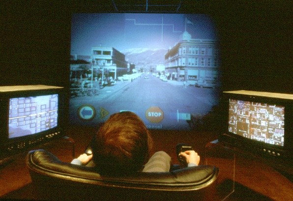
This map departed significantly from earlier immersive environments, such as the nineteenth-century panorama, in its interactivity. As historian of technology Aubrey Anable argues, one can think of the joystick as the central ideological feature of this interface. That is, the very interactivity integral to almost all digital technology today was, at the time, a political maneuver responding to both techno-paranoia and racialized fears of urban crisis.11 Arch Mac founder Nicholas Negroponte summarized the hysteria surrounding the advent of digital technology in his seminal book The Architecture Machine: “As soon as intelligence is ascribed to the artificial, some people believe that the artifact will become evil and strip us of our humanistic values.”12 In a debate waged along similar lines, urbanist intellectuals lamented the changes to the landscape occasioned by midcentury urban renewal programs, attributing “the perceived dehumanizing effects of the city to the cold right angles and superblock housing of brutal modernism and the social welfare state that it came to stand for.”13 The Movie Map and other Arch Mac projects, in turn, conceded to popular fear that systems—architectural or technological—would subsume the individual. These projects, as an alternative to subsumption, centered the individual as a thinking, active urban citizen. In the Movie Map, the user, rather than the programmer, determines what will appear on their screen; the user, rather than the planner, determines what their city will look like based on their own navigation. As Stewart Brand, pioneer of the early internet, wrote, “For the first time, the viewer could be thought of as an animal instead of a vegetable, active and curious instead of passive and critical.”14
Although this turn away from urban renewal was grounded in legitimate concerns about an anti-human affect of some of that era’s architectures, technologies, and policies, this hyper-individualistic, cybernetic response brought its own set of problems. Arch Mac’s experiments had decidedly conservative policy implications within this milieu at MIT, where systems engineers—most notably, Jay Forrester—advocated for self-regulating cities. Urban planning, he posited, “instead of dealing with problems and their solutions, could deal with the design of social systems to produce systems less likely to generate problems.”15 In other words, in place of policy changes—which Forrester saw as largely inconsequential within “complex systems” like cities—urban planners should establish networks that learn from their mistakes and adapt, in turn. Central to both the Aspen Movie Map’s interface and Forrester’s policy prescriptions is the idea of “feedback”: the user inputs directional commands into the computer and the urban citizen inputs money and behaviors into the city. Both the computer and the city adapt and learn from data input. And vitally, in both instances the programmer or the planner (and indeed, the state) is erased from the interaction in a gesture toward unmediated freedom.
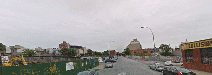
Today at the MIT Media Lab, the relationship between urban change and digital representation is more obvious. The Media Lab’s Streetchange project, for example, uses Google Street View to track demolition and development in five major US cities over the last decade.16 The project makes use of one of Street View’s most novel and, in many cases, harrowing features: the ability to go back in time. Because Street View drivers have photographed most streets every year or two since 2007, a user can track the visual change that has occurred during this period. Data gathering over the past decade has left behind a nearly encyclopedic index of urban transformation since the aughts. In certain instances, the changes are dramatic enough to remind viewers of the fragility of the built environment—via GIF, the ease of demolition and the speed of construction are rendered even more dramatic than they can be at reality’s pace.
What the project obscures, however, are the ways in which Google, following the Aspen model, is instrumental to the very changes it archives. By 2010, for instance, it had become clear that Google was gathering information from private Wi-Fi signals at the homes and businesses they drove by, culling “names, telephone numbers, passwords, messages, emails and chat transcripts, as well as records of online dating, pornography, browsing behavior, medical information, location data, photos, video, and audio files.”17 The mapping project was, in fact, far more insidious, and expansive, than simply charting streets; Google was attempting to map the desires and preferences of all the people (i.e., consumers) on Earth. What the company shows through Street View, but does not articulate, is that its own growth—the refinement of its own strategy—runs parallel to the visual transformation it documents. As we watch high-rises spring up in Brooklyn’s Bed-Stuy, we also take stock of the data-to-profit empire, represented recursively within itself.
Articulated in the 1970s as individual freedom—to navigate, to contribute, to control—urban space and technologies via input has today morphed into the corporate freedom to harvest data. And more recent instantiations of the feedback city are all too familiar. Unchecked real estate development comes at the expense of public input (the system adapts to this particular piece of data by ignoring it, a process the activist Bianca Wiley has called “engagement theater”).18 When Google’s corporate restructuring in 2015 birthed Alphabet, Google Maps and Sidewalk Labs (Alphabet’s “smart city” apparatus) united under one parent company. Now, the once tandem but separate processes of modeling and making cities serve the same bottom line. Feedback now means that democratic engagement has been reduced to data input in “smart cities” where, as Shannon Mattern has written, people serve as passive data points in the production of an entirely automated landscape.19 Rather than inhabiting a public sphere that responds to its citizens’ material needs, urbanites offer up their commute times, trash volume, and online shopping information in service of efficiency. The rationale for interactivity in the Aspen Movie Map and Forrester’s early-stage smart cities in the 1970s and ’80s was quite similar: to make people feel as if they were contributing to the production of their environment through feedback, when in reality, their world was designed using other input they didn't realize they were giving.
With little to no government oversight, Google is rarely forced to defend the ideologies implicit in its interfaces and world-making practices. When it is, the role of interactivity in city-building and city-rendering is justified as natural, neutral, and good because of its connotations of autonomy, mutability, and, above all, freedom. Of course, these are largely formalist conceits. As more vital social supports enabling comfort and choice in one’s life began to narrow in the 1980s and ’90s, and as the possibility of upward mobility became increasingly unlikely, the freedom to personalize the digital world grew exponentially. Americans can now, through Google Street View, take virtual vacations from their living rooms, even if austerity measures and stagnating wages mean that large swaths of the population will never be able to afford these luxuries. Or, as Rickard shows, users can navigate the very racial and class hierarchies that underlie techno-utopianism—writ small on their screens.
Faced with the pernicious and inescapable relationship between digital surveillance and urban inequality, A New American Picture returns its viewers to the comforting terrain of social documentary photography, even as the liberal, New Deal state that the genre emblematizes has ceased to exist.
Writing in 1981, artist Martha Rosler critiqued social documentary as a means of reinforcing the social relations it seems to condemn. “Poverty and oppression are almost invariably equated with misfortunes caused by natural disasters,” she writes of the genre. “Causality is vague, blame is not assigned, fate cannot be overcome. Liberal documentary blames neither the victims nor their willful oppressors.”20 Rosler examines the work of Jacob Riis and the FSA photographers, those progressive reformers upon whom Rickard draws heavily for historic precedent in his experimental internet art. Their influence is clear. Updated and tweaked for the digital world, the muckrakers who charitably humanized the victims of poverty are now the net artists for whom interactivity signals intimacy.
Rickard is remarkably imperceptive about the politics of his work, articulating its rehearsal of liberal documentary as a social good. For him, Google Street View is an appropriate tool, in its surveilling condescension, for representing poor, usually Black, American neighborhoods, whose residents he sees as living “an apocalyptic type of existence where you’re largely invisible, where you’re powerless for the most part, where you’re almost out of the public eye. Ironically, you’re in Google’s eye.”21 Google’s “eye” has particular formal characteristics that reinforce Rickard’s preconceptions about powerlessness. “The height of these cameras,” he says, “almost embeds a looking down on. The technique they applied almost feels like a level of disrespect to me. And that was fitting to the way that I felt about a lot of these communities that I wanted to look at.”22
In their complete detachment from lived experience, Rickard’s comments embody remarkably well the failings of his own work, which is to say, its success as an exemplar of the social documentary genre. The born-digital white photographer cannot but speculate what it might be like to be Black, poor, and confined by such architectures because he has no relationship—not geographically and certainly not personally—to his subjects. Yes, he feels empathy, a value understood, in many cases, to be a positive affective response to art—perhaps even the political use of documentary photography. But even that has significant limits. In “humanizing” his subjects, Rickard embodies the very mechanisms of Google’s interactive empire. As Rickard crouches down to the scale of the individual person, embedded deep within the map, he renders the very real systematic problems producing the misery he represents all but invisible. (As Rosler instructs, all this genre communicates is the misery, not the misery’s origins.) In a similar process, as viewers navigate the immersive map, preoccupied by the inner workings of this world only slightly different from the one they know, they cannot see that it is merely scraps of visual data. The larger trove is what dictates their world.
All this notwithstanding, Google Street View is here, now, and it offers a massive, and quite powerful, visual encyclopedia. It is a technology that begs for an artistic response.23 A New American Picture is a useful interpretation of this mandate insofar as it points to a historical consonance between urban development and surveillance. But all Rickard can do is despair in the problem he allows his viewers to see. Beyond its call for empathy, A New American Picture offers no politically viable alternative to the situation it documents. What would it look like to use a tool of digital surveillance to create art that does not capitulate to the inevitability of surveillance in modern life, that does not anguish in the relationship between immersive mapping and the urban environment?
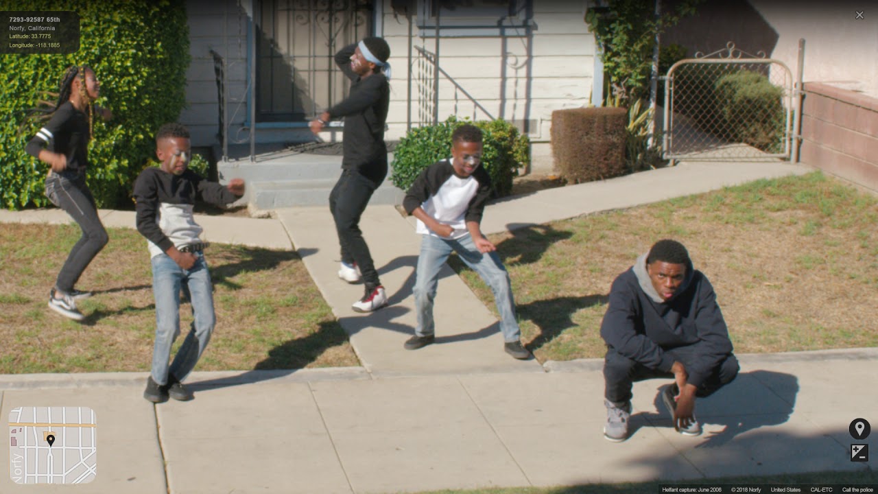
It is fitting that one answer to this question is a work born itself within the confines of the digital empire. Directed by Calmatic, a filmmaker from South-Central Los Angeles, the video that accompanies Vince Staples’s 2018 song “FUN!” depicts Ramona Park in Long Beach, where Staples grew up, as seen through Google Street View.24 But in this version of the technology, the streets of Ramona Park aren’t quite Google’s, nor are they the streets known in the real world. In this iteration of digital mapping, people—young Black men, women, and children—have digitally visual lives that are both dynamic and devastating, overpoliced and fun. They have unblurred faces and moving, living bodies, not the frozen, blurred ones they would have on Google Street View. Over the course of the music video, they light a vigil for a shooting, throw things at the Street View camera, get in a street fight that an onlooker records on her phone, play double Dutch, and steal a white neighbor’s bicycle. They also steal her phone, which she’s using to call the police, who then arrive and arrest Staples and his peers. They do it all in the space of an alternative Google Street View until, at the very end of the video, the user who’s been navigating the scene is revealed: He’s a tweenage white boy sitting in his room on his laptop. The video ends when his mother calls him to dinner. As if afraid someone will think his virtual wanderings improper, he quickly shuts his laptop, and the video cuts to black.
In the last moment of the video, viewers realize what they have actually been watching: the watcher himself. One might think of “FUN!” then, as an example of what Simone Browne terms “dark sousveillance.” Browne contends the surveillance of Blackness long predates the internet, noting its historical lineage from slave patrol to stop-and-frisk. But so, too, she argues, do forms of resistance, appropriation, and countersurveillance. Drawing on the work of Steve Mann, who defines sousveillance as “observing and recording by an entity not in a position of power,” Browne’s dark sousveillance understands turning the camera around, literally and metaphorically, during the digital age and before, as a crucial mechanism of the Black freedom struggle. 25 If the state employs CCTV networks, electronic monitoring ankle bracelets, and aerial surveillance to watch, control, and suppress Black freedom, then for Black Americans to record police violence on an iPhone and upload it to the web is to informally operationalize networks of digital control in the name of dark sousveillance. So, too, is to steal the iPhone from the white gentrifier, preventing her from doing “cop work,” or recording Black crime, as do the boys in “FUN!” So, too, is to watch the watcher.26
In its deployment of dark sousveillance, “FUN!” does what A New American Picture cannot, revealing the epistemological limits of Google Street View rather than simply reinscribing them. Rickard’s depiction of nearby Watts in A New American Picture reads as static and unimaginative in contrast to “FUN!” In that photograph, the Google camera captures men outside of a one-story liquor store: one man sits on a milk crate; another, on the hot pavement. Viewers can see economic desperation, certainly, but not all that it produces in resistance.
Astonishingly, Staples and Calmatic do not abandon the map altogether. They remain tethered to surveillance, a reminder that poor, Black urban life, when it reaches the white middle class, is so often mediated through that form. Urban life in Ramona Park is certainly not entirely self-determined, but when viewed through the tool of Calmatic’s, rather than Google’s, making, its perception, at least, can be. “FUN!” recognizes the failure of the justice system and the devastation of gun violence, for example, while also offering an alternative to total subsumption into the digital system. In its fantastical reproduction rather than strict appropriation of Google Street View, the video imbues the digital map with a liveliness—not just humanity—of which it is so often devoid. It overperforms the same fantasy of poverty upon which Rickard’s work relies, while undercutting it with a wink. In this version, subjects have more power than their cowering spectator; on this new kind of map, only slightly different from the one we know, a new kind of life emerges.
I introduce a music video here, at the end of this essay, to underscore that images can indeed form an axis of struggle. Especially when the struggle is subverting the logic of technology, a work that asserts alternative ways of living into a tool so focused on indexical rationality can be liberating. Rather than fleeing the all-encompassing problems of techno-capitalism—and its offspring in labor exploitation, environmental degradation, and urban segregation—“FUN!” leans into them, head-on. In so doing, it helps viewers remember the value of irony, dance, humor, the pursuit of justice, and the vivacity of urban life, even as it slips away. Indeed, if sincerity is a hallmark affect of liberal surveillance, including A New American Picture, then humor is central to sousveillance, including “FUN!” Especially in the period of isolation from which I write, the map, and the digital world more broadly, begins to feel like all we know—like life itself. At its best, Google Street View art can remind us of how much has been left off of the map.
-
The title of this essay is derived from T. S. Eliot’s The Waste Land, in which the phrase “unreal city” recurs. In that context, it gestures toward the modernist challenge of representing the urban world as it became increasingly alienated and homogenized. Although my interest in forms of urban representation considers digital media’s relationship to class and racial hierarchy, I take cues from Eliot’s attention to the perversion of urban social relations. Opening epigraph from György Kepes, Arts of the Environment (New York: G. Braziller, 1972), 8. ↩
-
Doug Rickard, “A New American Picture,” April 25, 2012, Annenberg Space for Photography, Los Angeles, recorded lecture, 63:46, link. The Annenberg Space closed in 2020 due to the COVID-19 pandemic. ↩
-
Doug Rickard, “A New American Picture.” ↩
-
Dan Lees, New Photography 2011, Museum of Modern Art, September 28, 2011–January 16, 2012, link. ↩
-
Geoff Dyer, “Street View,” The Believer 90, June 1, 2012, link. Comparisons of Rickard to Evans, in particular, abound. In a PBS NewsHour broadcast, for example, SFMOMA curator Erin O’Toole states, “Doug has a similarly social documentary purpose behind this work,” referring to Evans. See Scott Shafer, “Photographer Puts New Spin on ‘Street’ Art Using Google Maps” (San Francisco: KQED, October 29, 2012), television newscast, 7 min., 11 sec. See also, Hermione Hoby, “Google Muse: The New Breed of Street Photographers,” The Guardian, July 14, 2012; Diane Smyth, “The View from the Streets,” British Journal of Photography, February 22, 2011; John Foster, “A New American Picture: Doug Rickard and Street Photography in the Age of Google,” Design Observer, January 1, 2012; Brian Appleyard, “They’ve Been Framed,” The Sunday Times Magazine, December 11, 2011. ↩
-
Teju Cole, “Google’s Macchia,” in Known and Strange Things (New York: Random House, 2016), 182. First published under the same title on The New Inquiry blog, May 29, 2013, link. ↩
-
Reif Larsen, “How to See the World When You’re Stuck at Home,” New York Times, March 24, 2020, link. Michael Kimmelman’s virtual tours of New York neighborhoods published in the New York Times over the past year have taken a similar approach. See link. ↩
-
In the nineteenth century, for example, the stereoscope and panorama both sought to bring immersive travel experiences to residents of major American and European cities. See Dietrich Neumann, “Instead of the Grand Tour: Travel Replacements in the Nineteenth Century,” Perspecta 41 (2008): 47–53. ↩
-
Orit Halpern, “A History of the MIT Media Lab Shows Why the Recent Epstein Scandal Is No Surprise,” Art in America, November 21, 2019. ↩
-
Molly Wright Steenson, “Augmentation and Interface Tracing a Spectrum,” in Computer Architectures: Constructing the Common Ground (London: Routledge, 2019), 87–88. It is, of course, worth noting the contrast between Aspen, the hyper-elite locale, where the mapping interface was researched and designed, and its intended application sites in overseas war zones and American cities. As Halpern writes in Art in America, “The violence for which these systems were built was rendered invisible; geo-politics was subsumed by immersive media.” For more on the relationship between hypermedia and urban warfare, see Jennifer Light, From Warfare to Welfare: Defense Intellectuals and Urban Problems in Cold War America (Baltimore: Johns Hopkins University Press, 2003). ↩
-
Aubrey Anable, “The Architecture Machine Group’s Aspen Movie Map: Techno-Paranoia and Urban Crisis in the 1970s,” Television & New Media 13, no. 6 (November 2012): 498–519. ↩
-
Nicholas Negroponte, The Architecture Machine: Toward a More Human Environment (Cambridge, MA: MIT Press, 1970), 1. ↩
-
Anable, “The Architecture Machine Group’s Aspen Movie Map,” 515. ↩
-
Stewart Brand, The Media Lab: Inventing the Future at MIT (New York: Viking, 1987): 141. ↩
-
Jay Forrester, “Planning Under the Dynamic Influences of Complex Social Systems,” in Arts of the Environment, ed. György Kepes (New York: George Braziller, 1972), 152. ↩
-
“About Streetchange: Computer Vision Uncovers Predictors of Physical Urban Change,” MIT Media Lab, Last modified 2017. ↩
-
Shoshanna Zuboff, The Age of Surveillance Capitalism: The Fight for a Human Future at the New Frontier of Power (New York: PublicAffairs, 2018), 130–133. ↩
-
Bianca Wiley, personal communication (September 16, 2019), quoted in Shannon Mattern, “Post-It Note City,” Places, February 2020, link. ↩
-
Mattern, “Post-It Note City.” ↩
-
Martha Rosler, “In, Around, and Afterthoughts (on Documentary Photography)” in Decoys and Disruptions: Selected Writings, 1975–2001 (Cambridge, MA: MIT Press, 2004), 177. ↩
-
Rickard, “A New American Picture.” ↩
-
Rickard, “A New American Picture.” ↩
-
The genre of Google Street View art is much larger than Rickard. Each artist has a slightly different focus: Emilio Vavarella shows the faces of Street View car drivers that accidentally end up on camera; Paolo Cirio prints figures from Street View onto wheatpastes that he reinserts into the urban environment where they were originally photographed; Michael Wolf and Jon Rafman each zoom in on moments of impropriety in the public sphere. ↩
-
Calmatic, “FUN!” performed by Vince Staples (2018; Los Angeles: Conway Recording Studios, 2018), music video. ↩
-
Simone Browne, Dark Matters: On the Surveillance of Blackness (Durham, NC: Duke University Press, 2015), 1–29; and Steve Mann, “Veilance and reciprocal transparency: Surveillance versus sousveillance, AR glass, lifeglogging, and wearable computing,” 2013 IEEE International Symposium on Technology and Society (ISTAS): Social Implications of Wearable Computing and Augmediated Reality in Everyday Life (Toronto, ON, 2013): 3, quoted in Browne, Dark Matters, 19. ↩
-
For Browne’s discussion of “cop work,” see her keynote lecture, 43rd Annual Scholar & Feminist Conference, “Subverting Surveillance: Strategies to End State Violence,” Barnard College, New York, New York, February 17, 2018, link. ↩
Ella Comberg is a curatorial fellow at Slought in West Philadelphia and an editorial assistant for the Archives of American Art Journal. In 2020, she graduated from Brown University where she studied the history of art and architecture and urban studies. Her thesis examining A New American Picture was named best history of art and architecture thesis at Brown University.