
君不见,黄河之水天上来
Do you not see the Yellow River come from the sky?
—poet Li Bai (Tang Dynasty)1
The Qinghai-Tibet Plateau is often called the water tower of the world. As the source of most of Asia’s significant rivers—the Indus, Ganges, Brahmaputra, Irrawaddy, Salween, Mekong, Yangtze, and Yellow Rivers—the plateau provides water for more than two billion people downstream. In the Yellow River’s catchment, traditional—if extraordinary—water management techniques are reaching their upper limits. Severe stress on available water in the North China Plain, nearly half of which comes from Qinghai-Tibet, is tied to burgeoning consumption, water-intensive agricultural production, and industrial activities. Fears over its future scarcity due to climate change and the depletion of glacial reserves in the Himalayas have led the Chinese government to implement water precipitation enhancement technologies at a dramatically increasing scale.
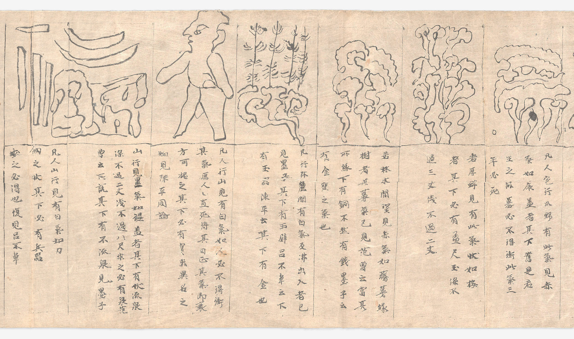
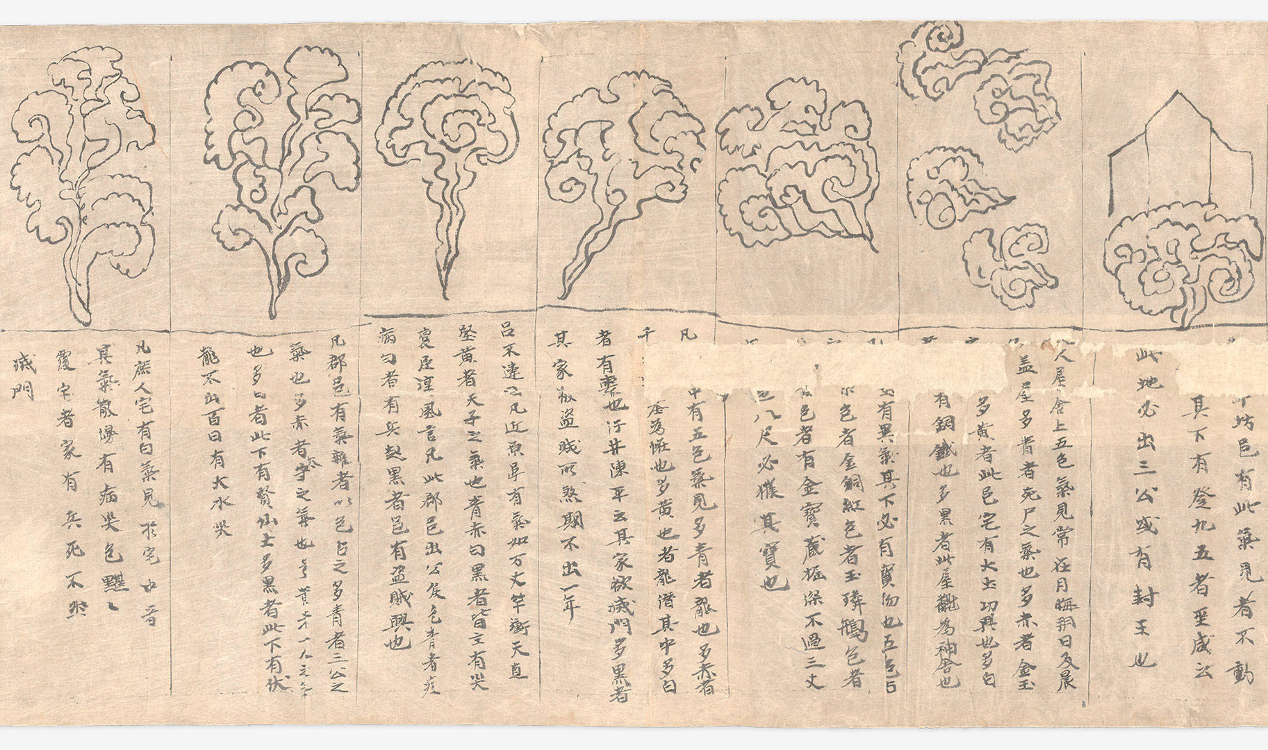
The desire to control rain is not new, and it is not unique to the People’s Republic of China. To tell the story of the Sky River—both the conceptual model and the weather modification project—is also to learn the hydro-geographical history of China, which has actively manipulated its relationship to water for thousands of years, and has been developing weather modification technologies since the 1950s. One of these technologies is the cloud seeding stove (人工增雨烟炉), a rudimentary metallic envelope on a short pedestal that encases a high-performance combustion chamber, employing military rocket engine technology to burn a chemical compound of silver and potassium iodide. The stoves are installed on elevated terrain and strategically positioned at high altitudes where upward winds deliver the chemical exhaust into cloud formations above to trigger rain. A discrete object built and replicated across China, the stove is where and how the physical embodiment of the Sky River—as both phenomenon and project—is seen for the first time.
In the troposphere above the Sanjiangyuan (三江源, the Source of the Three Rivers) area of the Qinghai-Tibet Plateau is the testing site where a confluence of water vapor conveyance channels—sky rivers—have been identified. Sky rivers are a conceptual model of water vapor transport that can, hypothetically, be turned into precipitation through the Sky River Project, a distributed infrastructure of ground and orbital machinery. While a constellation of satellites observes and monitors atmospheric conditions, the network of automated and remotely operated stoves is placed strategically to modify the spatio-temporal distribution of precipitation above this pilot region: to make it rain. As a testing site and a hypothesis, the Sky River Project—one of the largest and most ambitious weather engineering projects to date—extends national extractive claims upward into the atmosphere.

The Third Atmosphere
What kind of a thing is a cloud?
—Masanao Abe2
The atmosphere-ocean environment of planet Earth has evolved slowly over some four and a half billion years.3 Its current atmosphere, the third in Earth's history, is a gas and aerosol envelope extending out from land, ocean, and ice toward outer space, held in place only by the planet’s gravitational pull. The atmosphere is most dense near the surface of the Earth, where gravity pulls gases and microscopic particles of dust, smoke, and chemicals inward to settle on the surface, where they are absorbed by its organism-inhabitants. The lives of these inhabitants are protected by the creation and maintenance of pressure that allows water to exist in each of its three phases: solid, liquid, and gas. Together, these multiple states contribute to climate regulation by allowing for the absorption of solar radiation, the needed warming of the planet’s surface by the retention of heat, and the reduction of changes in temperature between day and night. The atmosphere contains a variable amount of water vapor, an estimated volume of 37.5 million-billion gallons. Particles of water vapor move into the atmosphere from bodies of water (evaporation) or the exhaling of leaves (transpiration). As the particles are carried up and out into the atmosphere by wind (advection), they meet aerosols—sometimes the result of natural sources like volcanoes, sometimes the result of human activities like air pollution. Some of these aerosols are hygroscopic: both attracted to and ready to hold water vapor. If the conditions are right, and if they find themselves in a stable but saturated parcel of air, these aerosols pull water vapor particles in, becoming the cores of cloud droplets. This moment of saturation is also known as the dew point, when the congregation of droplets—a cloud—grows in volume, weight, and height until they fall back down toward the surface of the Earth.
At any given moment, approximately two-thirds of the planet is covered by clouds.4 These masses of microscopic droplets assist in the distribution of the Sun’s energy while storms push and pull energy from the equator to the poles and back—a process that may seem straightforward, but “grows increasingly complicated as heat, evaporation, turbulence, radiation, wind, geography and myriad other factors come into play.”5 Nephology, the science of clouds, requires an understanding of the entire atmosphere, including all of its dynamics and externalities. It is no coincidence, then, that one of the great challenges to climate change prediction is the inadequate representation of cloud processes. Although ground-based observations exist, according to a NASA report, “scientists require frequent observations (at least daily), over global scales (including remote ocean and land regions), and at wavelengths throughout the electromagnetic spectrum (visible, infrared, and microwave portions of the spectrum),” so that they might approach the possibility of verifying their model predictions.6 To further their understanding of clouds, NASA has instruments on the Afternoon Constellation (A-Train) satellites Aqua, Aura, CALIPSO, CloudSat, and Terra. Scientists believe the A-Train will allow them to observe the movement of clouds around the planet along with their vertical structure: they will see the clouds from inside.
In the troposphere, the lowest region of the atmosphere where we live, water vapor also exists in the form of filamentary structures—and in a state of constant flux. In 1992, a group of scientists from the Massachusetts Institute of Technology and the NASA Goddard Space Flight Center proposed naming these filaments tropospheric rivers, as they had the characteristics of the rivers that we know on land: places where water gathers to move in “lengths many times their widths and persist for many days while being translated through the atmosphere.”7 Their finding originated as a fortuitous observation within NASA’s Measurement of Air Pollution by Satellites (MAPS) program, aimed at providing a near-global map of the distribution of carbon monoxide in the lower atmosphere.8 Startled to see thermal fingerprints of the air polluting molecule located far away from any potential source of emission—but limited by the capabilities of MAPS, which was not capable of sensing through clouds—the scientists turned to data provided by the Total Ozone Mapping Spectrometer (TOMS),9 an instrument designed to return a more detailed portrait of the atmosphere by measuring the wavelengths of back-scattered solar radiation.10 Through the reflectivity data provided by TOMS, they saw moisture pathways connecting the concentrations of carbon monoxide to their source regions. Water vapor, they inferred, was responsible for the transport of carbon monoxide in the troposphere over long distances. After establishing the persistence and volume of these so-called rivers, the authors asked: “Can any practical use be made of the apparent relation, revealed through serendipity, between TOMS images and lower atmosphere water vapor flux?”11 Just two years later, Newell and Zhu, two of the paper’s authors, were able to determine that these filamentary structures are, in fact, responsible for the transport of almost all of the water vapor in the atmosphere, despite discharging only, on average, a third of the water they carry as either rain or snowfall. These vectors,12 which originate in the tropical and subtropical region and travel polewards, represent such frequent features of global atmospheric circulation that evidence of their presence can be observed in ice cores from Greenland and Antarctica.13
Sky Rivers (天河)
We don’t want to just write theoretical essays, we want to write essays on the ground. For the Yellow River to flow continuously, we have been working for 10 years; we also want to do this for 10 years to see if we can find a new way to solve the water shortage of the Yellow River.14
—Wang Guangqian, principal investigator of the Digital Yellow River Model, president of Qinghai University, and leader of the Sky River team
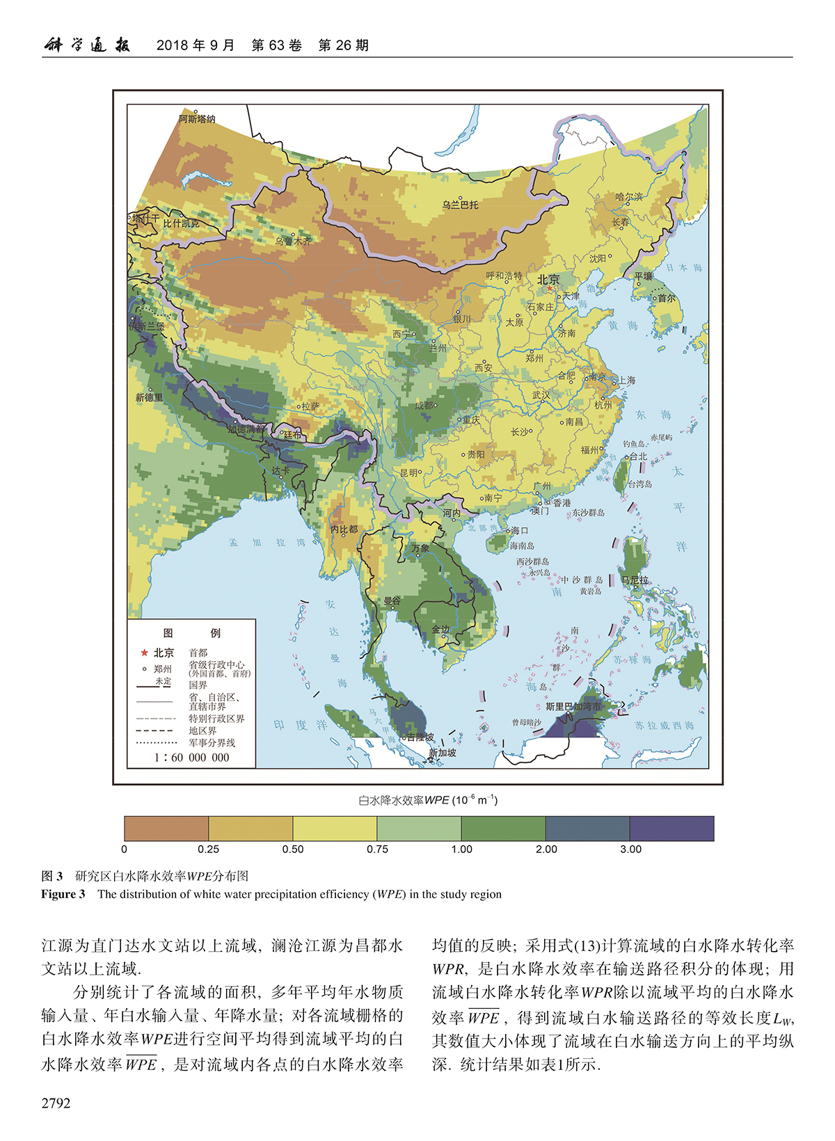
In a series of seminal papers published between 2016 and 2018 by Science China Press, a team of hydroscience engineers from Tsinghua and Qinghai universities proposed a new concept of atmospheric water: “white water.”15 Alongside the two already established types of water that are conventionally recognized as part of the hydrological cycle—blue water, found in “rivers, lakes, underground aquifers, and other sources that can be used by humans directly,”16 and green water, that “directly evaporates from the land surface and transpires from vegetation,”17—white water exists when and where moisture with a high potential to precipitate moves into “discontinuities in the atmospheric flow fields.”18 These special boundary layers, developed by air masses, are characterized by different gradients of temperature, velocity, pressure, or humidity, “when they meet each other in the troposphere.”19 The engineers and scientists named these discontinuities “sky rivers (天河),” specific bodies and durations of tropospheric water filaments that hold identifiable spatial and temporal dimensions.20
While previous research on atmospheric rivers has been focused on the transportation of water vapor and its short-term manifestation in extreme weather events, the attention of Wang Guangqian and his colleagues is on the “long-term configuration infrastructure” of atmospheric rivers so that they may be “fully brought into the water resources management systems.”21 If atmospheric rivers describe a phenomenon that can be directly observed through a combination of remote sensing and ground-based radar measurements, then sky rivers are a kind of calculation—a constructed model—explicitly devised for new forms of utilization and extraction, the facilitation of water resource management, and, potentially, the establishment of claims of state ownership:
...as a natural resource like others, the ownership of atmospheric water resource must be well clarified. For this purpose, we have to figure out whether there exists a concept of “basin” in the atmospheric water resources. And if so, where is the “basin”? How do[es] atmospheric water flow between the “basins”? Obviously, these two problems make the atmospheric water resources development no longer a simple meteorological issue.22
Sky rivers, then, require a double move: from terrestrial topography, where watersheds are determined by geomorphology, to a topography of winds and pressure gradients through which the catchments of sky rivers can be determined mathematically.23
Sky rivers are four-dimensional topologies of flow projected onto—and into—the sky. “The clouds in Qinghai,” according to Wang, “are different from those in Beijing. The clouds in Qinghai press[ed] on my head. I feel that the water in the sky is connected to the water on the ground. I thought of the sky river dynamic theory.”24 With Wang’s implicit invocation of Li Bai’s poetry—Do you not see the Yellow River come from the sky?—the cultural imagination of the Yellow River becomes a scientific one: if the Tibetan Plateau extends the presence of water vertically into the atmosphere, then the Sky River Project extends the structure of the river catchment into the fourth dimension, up in the troposphere and across time to locate sources of extraction—and to optimize their temporal instability. While transboundary river management is tied to the understanding of topography as organized by gravity, the interception of water vapor requires the imagining—and imaging—of global wind circulation as a latent topography of opportunities.
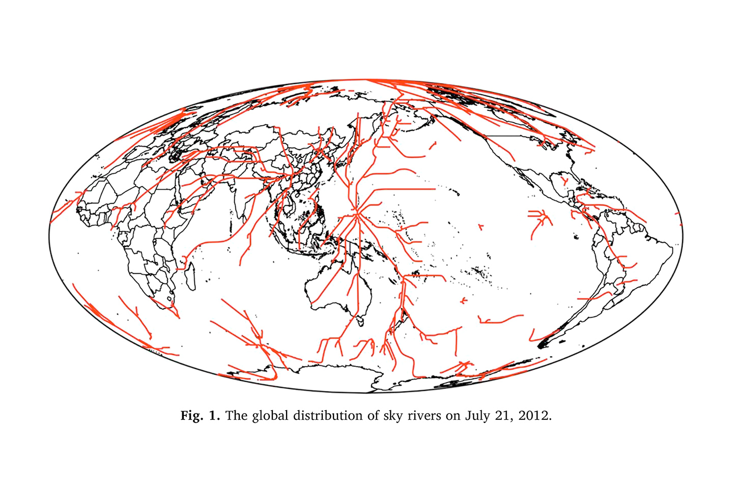
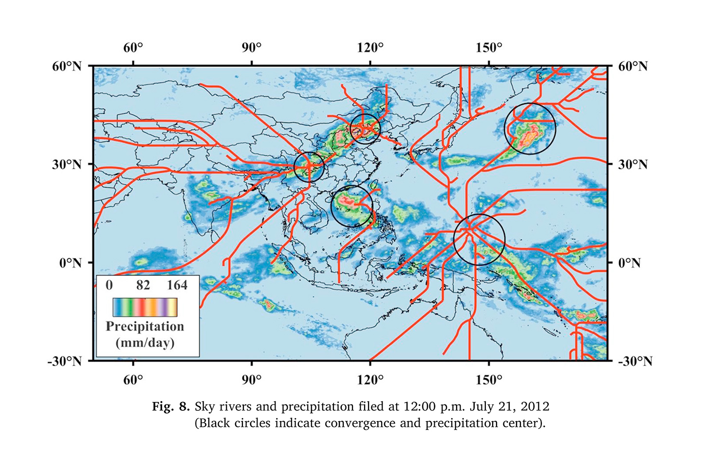
In most visualizations featured in the foundational papers, sky rivers are portrayed as linear structures or fractures across the Earth’s atmospheric continuum: a clear departure from the more conventional representations of atmospheric rivers, characterized by heat maps and vector field graphs. Sky rivers are depicted as a system of clear, stable pathways that define a hierarchy of primary and secondary streams and their confluences, similar to the classical diagrams of watershed analysis. Different states of wetness temporality are separated and made evident through these lines. This act of reduction and separation is deemed necessary to image water vapor into a river. While heat maps portray water and moisture in flux as snapshots of a field of forces wherein the atmosphere is imagined to be pictured as a whole, the lines of sky rivers seem to establish a long-term knowledge of recurrence—something that can be wired to an infrastructure.
In 1931, American hydrologist Robert E. Horton presented the now-ubiquitous hydrological cycle diagram in The Field, Scope, and Status of the Science of Hydrology. Horton claimed his circular diagram represented and “rest[ed] on the mathematical constitution of the water balance equation”25 and, in so doing, successfully established hydrology as an independent field of study. The Hortonian hydrological cycle is still considered a universal portrayal of the states of water, with an understanding of water as subject to regular patterns, despite having been modeled after conditions specific to the temperate climates where Horton lived.
If the diagram-as-definition of the hydrological cycle led to the establishment of hydrology,26 then a new science, the concept of white water—a temporal and spatial conjecture created through the optics of weather satellites and galvanized by the chemicals of the ground stoves—is also meant to establish a new understanding of the global water cycle and to set new boundaries for the field.27
The (Hydro-)Geography of China
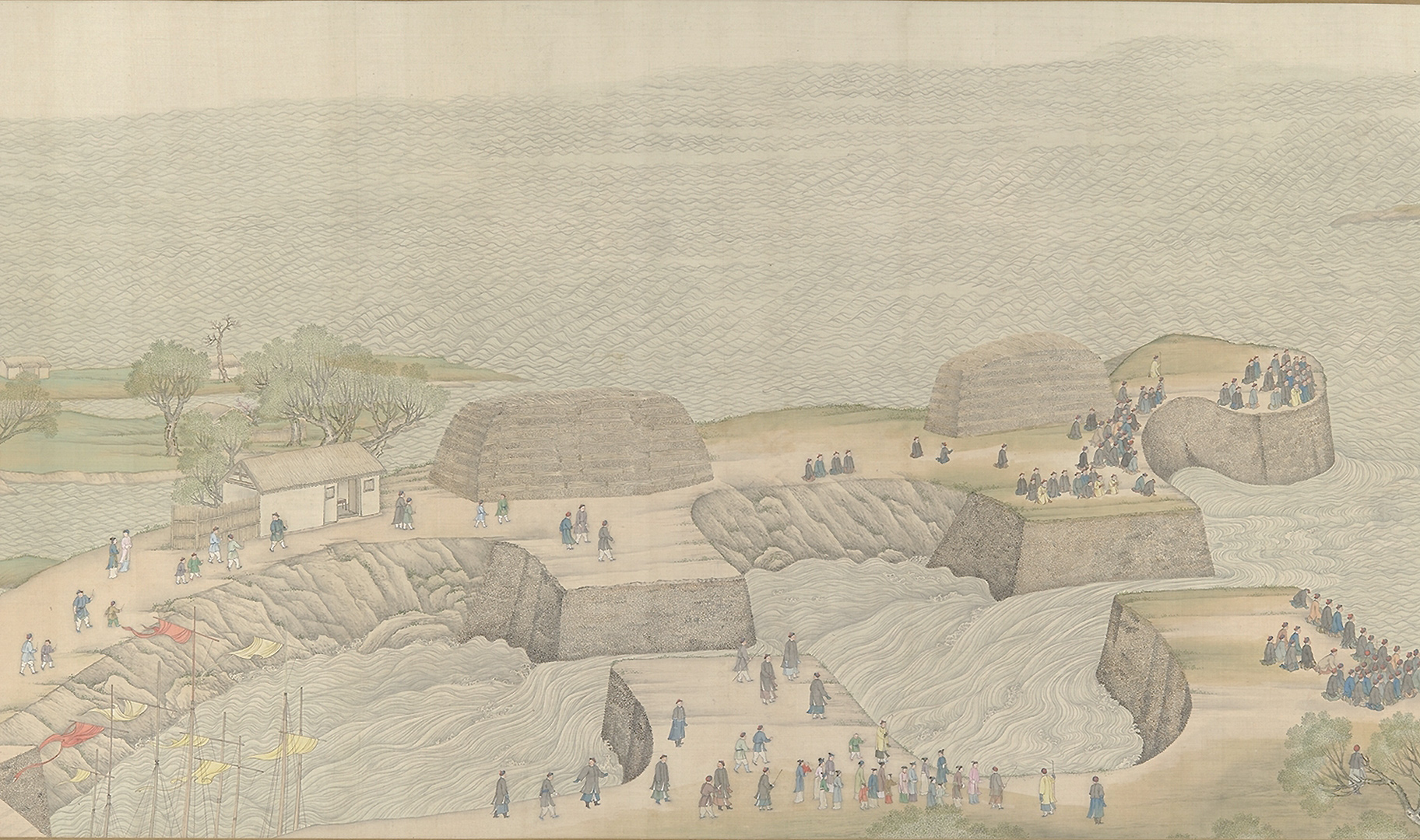
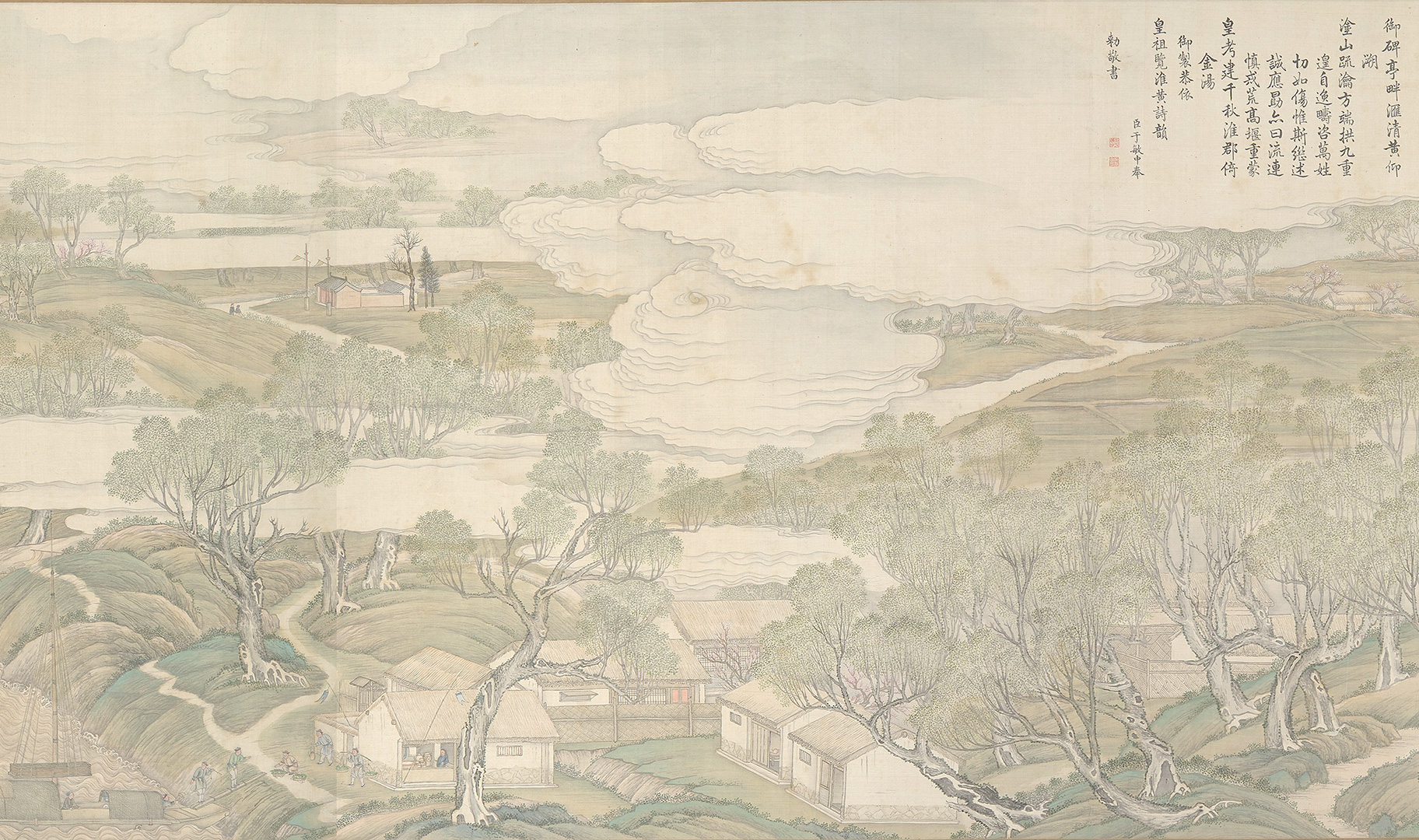
Sky rivers emerge from a history of water management that dates back thousands of years to the establishment of the Xia Dynasty, its founding sage king, Yu the Great (大禹),28 and the flood-based re-creation myth wherein Yu “established the proper order of the mountains and the waters”29 by “opening passages in the mountains and guiding rivers into their courses,”30 allowing the waters to flow naturally. It is not a coincidence that the root of the Chinese character “to govern (治)” is water; the lines of mountains and rivers that Yu traced out divided China into the “Nine Provinces.”31 According to scholars, including American sinologist and historian of ancient China, Mark Edward Lewis, the “mythology of the flood provided a background for accounts of the structure of the world, along with the forces that made that structure possible.”32 The story of Yu is the story of worldmaking, and it offers “a mythology of contemporary practices of water control, in both its literal and figurative uses”33 of “demarcation, division, expulsion”34 to achieve hydraulic stability of the Yellow River and flood control in the North China Plain.
The hydro-geography of China is the legacy of both centralized and local water management plans and the contemporary fluid relationships of consumerism and industrialization, which link the country to global markets. Historically focused on the North China Plain as an area of intensive agricultural production and demographic growth, Chinese water management projects had the Yellow River as their main stage. For the most heavily silted river in the world,35 the myth of a tamed river emerged alongside the engineering of its riverbed and landscapes. The more the river was changed and controlled, the more it pushed back, requiring ongoing intervention and tying the political destiny of the ruling class to negotiations with the river in the valley.36 Various understandings of water flows have been the state’s organizational backbone for centuries, binding the stability and fate of dynasties and other structures of power to their abilities to establish and maintain the particular arrangements of labor and control along the river.
The understanding of the Yellow River as an asset was tested most intensively in 1938, when, in a desperate move by the Nationalist Government to halt the Japanese invasion, the dikes were artificially broken to flood the plains and displace the river’s estuary, turning it into a defensive weapon. The prewar course of the river was only reestablished after 1947, with a coordinated effort by the United Nations Relief and Rehabilitation Administration (UNRRA). It became clear that the conditions of the North China Plain—and its ability to become the “breadbasket of the world”—were not only of Chinese concern. In the words of Oliver J. Todd, the chief adviser engineer of the UNRRA mission:
The fact that the lives and welfare of 50 million people are so closely tied up with this river’s behavior makes the problem intriguing to engineers and intensely interesting to those who are studying population growth and the question of how the world is to be fed. In a way the Yellow River is a world problem in itself.37
The modern geographical imaginary of the country is tethered to a rigid conception of water balance, where a scarcely populated, water-rich south is often placed in opposition to a densely inhabited and agriculturally developed but water-scarce north.38 This uneven distribution of water resources across the nine major river basins of the national territory is amplified by spatio-temporal patterns of precipitation. In an attempt to respond to this water crisis, two strategies are underway: the first is to increase rainfall through weather engineering, and the second is to offset water needs.
North China’s water stress is not only a national security concern; its growing population and industrial expansion have exponentially increased the impact of this demand on the global water balance, challenging the geopolitical stability of Central and Eastern Asia. As David A. Pietz argues, China is aggressively leasing farmland abroad to produce both food and biofuel crops (which are particularly water-intensive) to meet its emission reduction goals. These investments, along with the direct import of agricultural commodities,39 are a trade of water by proxy.40 While the majority of China’s irrigated farmland is in the north, its products mostly feed the heavily populated cities of the south, where wealthier dietary preferences demand water-intensive crops, alongside a spiking increase in meat consumption.41 As water moves northward through rivers, pushed through aqueducts and canals, pumped from aquifers to irrigate exhausted northern farmlands threatened by desertification, it also circles back south—inside food. Water flows in the atmosphere, above and below the ground but also through economies. The river is not a single stream but many streams that flow through bodies, territories, and data centers.
The Digital Yellow River Programme (DYRP) is a large-scale project of integrated river basin management aimed at creating a real-time representation of the “natural” Yellow River in a GIS-based virtual environment.42 Taking into consideration multiple inputs, from meteorology to geology, of economics to legislation, the DYRP is a platform that provides numerical modeling and centralizes decision-making processes on every aspect of river ecosystem optimization.43 The Yellow River is rendered and replicated into a network of gauges and sensors, data processing and storage centers, numerical models, and protocols of intervention—the sky river, which also exists almost uniquely in the form of numerical forecasting models, can be easily integrated, extending the headwaters of the Yellow River up into the atmosphere.
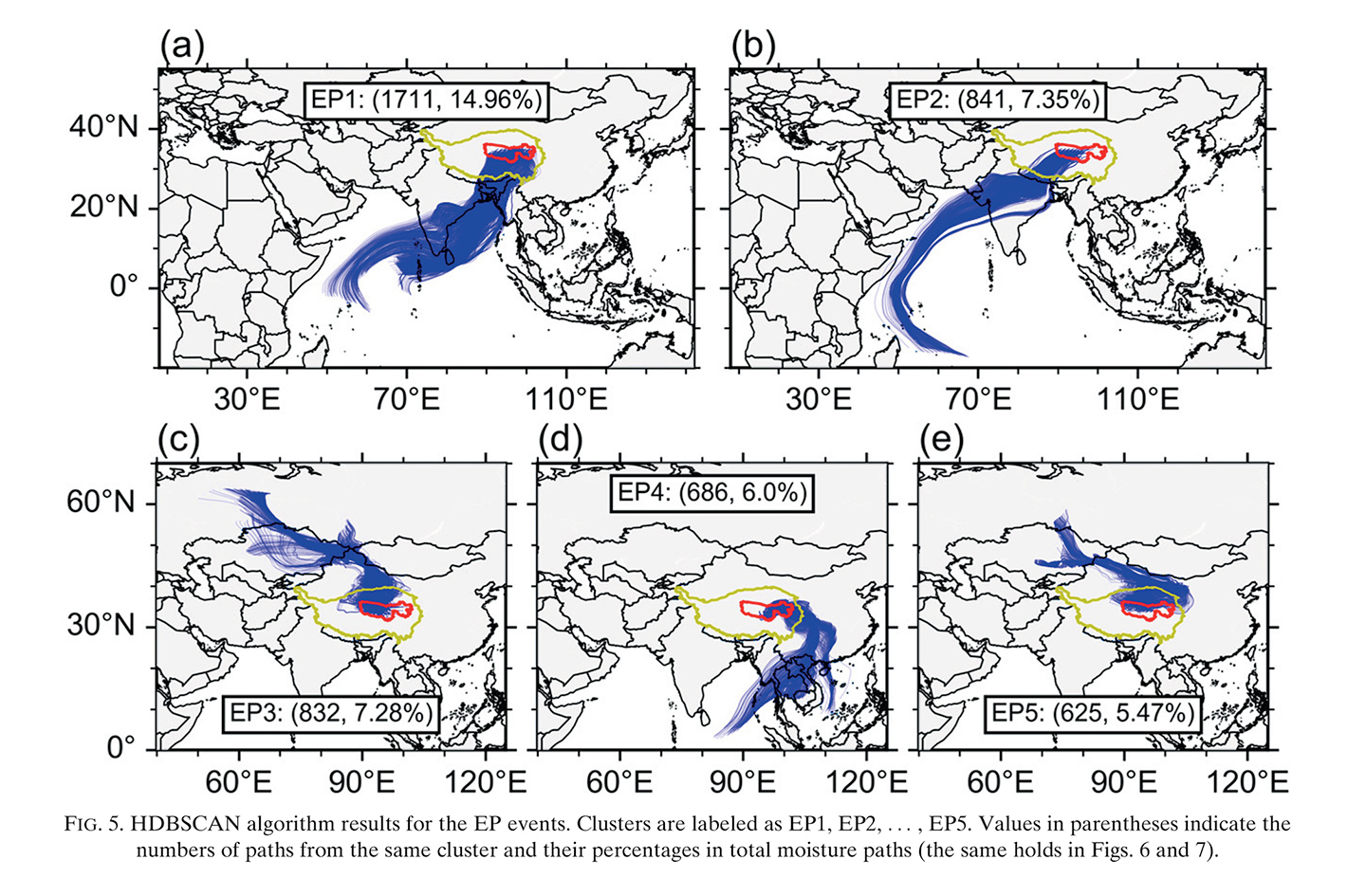
The total incoming water vapor of China is estimated to be close to 20 trillion cubic meters per year, approximately four times the average annual rainfall.44 This water vapor is delivered through various long- and short-distance channels, ranging from the Caspian Sea, the Altai Mountains, the Western Indian Ocean, and the Bay of Bengal. Smaller quantities of water vapor are conveyed by high-altitude winds originating above the Atlantic Ocean.45 Almost all of these channels enter the territory of China from the southeast,46 only partially discharging their water before reaching the height of the plateau.47 As the western route of the South-North Water Transfer project48 is deemed more and more unfeasible for its high costs and engineering challenges, the focus on water vapor implies a shift from the middle and lower reaches of the river to the headwaters and to the sky. The headwaters of the Yellow and Yangtze rivers are not confined to the plateau but branch off in multiple directions to the sources of each water vapor stream as they approach Qinghai-Tibet from above. In this move, the control (and the watershed) of the rivers’ headwaters is extended into the atmosphere.49 Here is where the rivers of the earth meet the rivers of the sky.
A Cloud-Seeding Stove
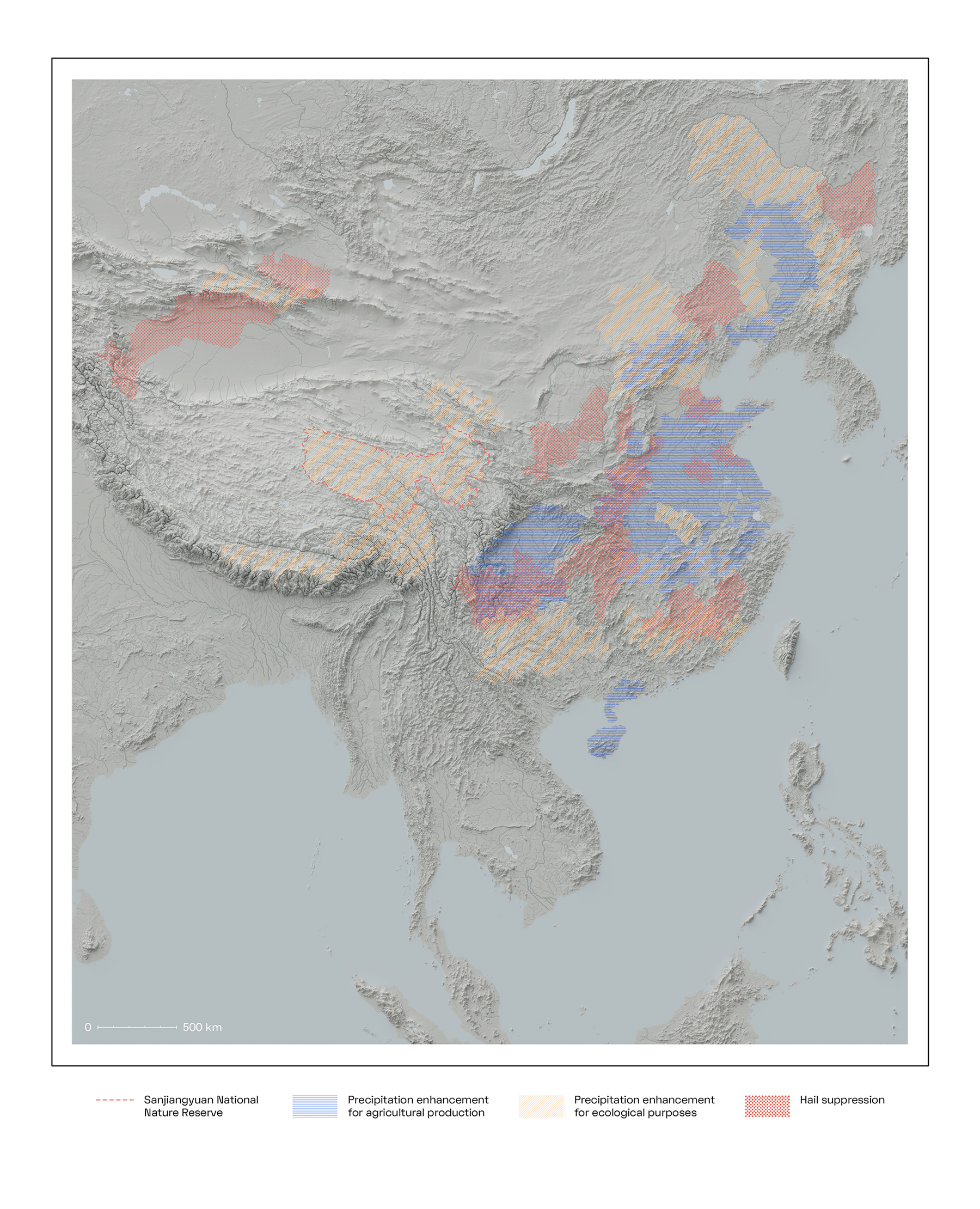
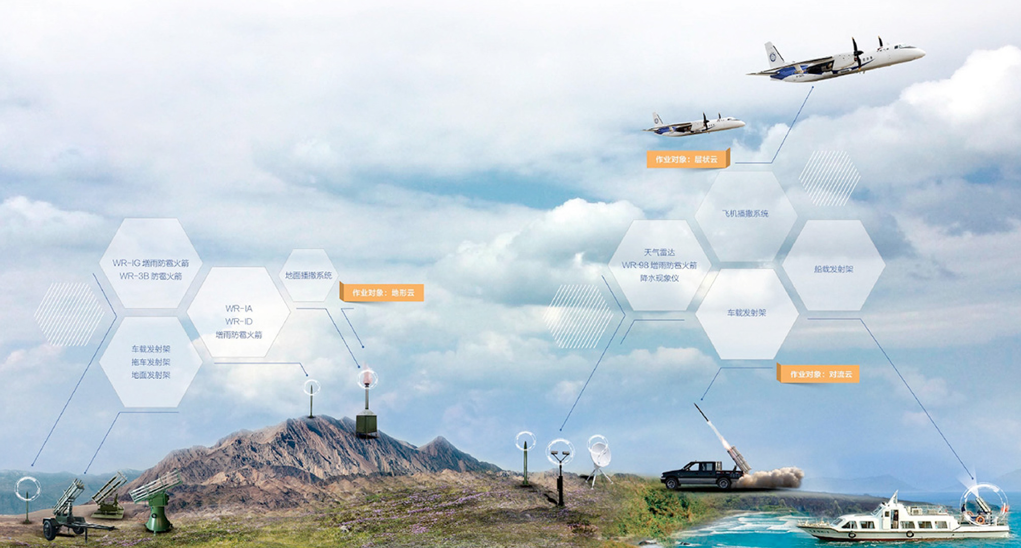
Rain enhancement and hail suppression operations are carried out on a regular basis in an attempt to safeguard and increase agricultural production, ensure drinking water supplies, restore ecologically damaged biotopes, and sustain hydropower projects.50 Recall Yu the Great: a significant portion of Chinese territory is organized into areas of precise meteorological intervention. This infrastructure is managed across four levels—national and regional, provincial, city, and county—where local weather bureaus make decisions with relative autonomy (and sometimes in competition with one another51), though all sit under the general helm of the China Meteorological Administration (CMA), according to policies established by the Meteorology Law of the People’s Republic of China.52 Weather engineering applications are meant to seed the sky; the scale and persistence of these operations has produced a vast geographical footprint throughout China, which is now being extended into the mountainous area of the Qinghai-Tibet Plateau.
Cloud-seeding stoves—ground-based silver-iodide generators—have operated across China for more than two decades as part of an apparatus that includes stationary and mobile rocket-launch systems (usually deployed on the back of commercial pickup trucks), aircraft, and UAVs.53 The “ground seeding furnace and control system BD-48”54 is the fourth iteration of a genealogy of similar devices manufactured by Shaanxi Zhongtian Rocket Technology Co., Ltd., a civilian-military contractor headquartered in Xi’an City, which is engaged in the research, development, and production of rocket technologies for civilian and military purposes. The stoves all share a similar design: they are solar-powered, their ignition is remotely controlled through GSM/GPRS technology, and their exhausts are conveyed to the sky through a chimney that can reach a height of about 5.5 meters. Cloud-seeding stoves are fastened with wind wire ropes to a concrete slab foundation that also hosts an automatic weather station and antennae for remote control and communication; a metal fence protects the installation from its immediate surroundings. The only variation is the metal roof, which sometimes presents a sweeping curvature resembling traditional religious architectures. On the exterior, they can display bright, solid colors, but the majority are painted dark green, easing their optical blending into background vegetation. They can be decorated with abstract shapes, camouflage patterns, or even the outline of an arched door corresponding to the aperture that grants access to their operating dashboard. More often than not, the four sides of the lower chamber are stamped with bold texts and icons claiming their belonging to the CMA and local weather bureaus.
While these exteriors—which can appear to be makeshift metalwork—are documented in countless photos posted on WeChat, Weibo, and websites of local administrations, the stove’s inner workings are concealed from view by a heavy metal plate that holds the bays for the flammable silver iodide bars. As of 2018, more than five hundred stoves have been installed for experimental use on the alpine slopes of the Qinghai-Tibet Plateau for a combined area of 110,000 square kilometers divided into three macro-regions: Sanjiangyuan National Nature Reserve,55 Qilian Mountains, and the Kunlun Mountains. While more specific place names are mentioned online,56 the actual locations of the test sites within these three regions are not disclosed.

This sprawling ground network will be met in the sky by a constellation of low Earth orbit satellites—a monitoring and forecasting system that will be able to quantify the volume and duration of atmospheric water transport—that activate the stoves when favorable meteorological conditions are met. This new satellite platform aims to enhance the sensing capabilities of the current and future Fengyun-4 family of geostationary Chinese meteorological satellites.57 Once operational, Tianhe-1, the first of a series of twenty-eight planned spacecraft,58 is meant to provide ecological monitoring of the Sanjiangyuan region while studying the temporal and spatial evolution of sky rivers to achieve a sky-air-ground integrated monitoring system for atmospheric water resource development.59 This satellite constellation is meant to guide the operations of a sophisticated platform of rain enhancement technologies, including telling the stoves when to fire up and when to turn off. From the coordinated communication and actions between these two seemingly heterogeneous, disparate networks emerges a new atmospheric-terrestrial infrastructure. “Infrastructure,” writes Ashley Carse, “[is] more than a word. It [is] worldmaking.”60 The stoves and satellites act as a network, actively participating in the transfer of water from transboundary atmospheric pathways to the Yellow River basin. In the projection of a three-dimensional metaphor onto a four-dimensional cloud topography, the interlocking polar orbits of the LEO constellation—or even the geosynchronous equatorial orbit61 of the current and future Chinese weather satellites—become an instance of the contentious atmospheric water basins presumed by the Sky River Project. The orbital paths of the satellites, as they perform their ecological monitoring duties, not only define the instrumental envelope of the Sky River infrastructure, but they highlight the very “infra in infrastructure: the logics of depth and hierarchy that manifest in design, management, and maintenance”62 and allow for the imaging of “white water,” without which sky rivers could not be imagined.
Transboundary Hydro-geo-logics of the Sky River
The Sky River Project is a paradigmatic act of geographical reimagination. The sky rivers bring with them a new understanding of global atmospheric circulation. In a conceptual leap, atmospheric water and conventional surface water are brought together in a long-term coupling that follows the way water gathers and flows in terrestrial rivers. Establishing a new theoretical framework for the hydrological cycle expands the domain of resource extraction to the atmosphere. The project and its assumptions are not without controversy, and there are critiques from the scientific community. Besides internal challenges that stem mainly from the debate over the project’s feasibility and its reframing of atmospheric and hydrological science, the project has raised concerns in neighboring countries, especially India. Still, proponents of the Sky River Project maintain this potential precipitation should be thought of as a readily available resource, a kind of standing reserve water supply, available to be displaced through this distributed network infrastructure.
If the topology of water is imagined as a continuous surface, water flows into the plateau through sky rivers and out of the plateau through rivers on the ground. In both cases, sensed and processed into data, these flows are already a resource even before becoming water. In the past, China has strategically refused to provide data for cooperative transboundary river management while simultaneously building new dams and adopting water-intensive cultivation in many of Central Asia’s watersheds. There exists a growing international suspicion that Sky River, a project set to exist in a space without clear boundaries and regulations, would take a similar approach at a much larger scale.63 China, its neighbors contend, is trying to control all resources in all directions. This control is both spatial and temporal: dams and reservoirs are time-management infrastructure, regulating rain and runoff, making surface waters—otherwise obscured by their uneven temporal distribution—visible by collecting and then storing them in plain sight. The Sky River Project seizes upon this logic of optimization and resource visibility, coordinating remote sensing and stove activation to tap into the sky rivers fluctuating and pulsating above.
Water vapor is not a stable feature of planetary origin but of the atmosphere. Its fundamental composition and materiality challenges us to overcome our familiar principles of direct, Cartesian verticality when conceptualizing borders and boundaries. Projecting the topology of the watershed up into the sky with wind, temperature, and pressure as vectors, a vertical appropriation takes hold, extending principles of terrestrial sovereignty into the atmosphere.64 Ultimately, the exploitation of the atmosphere fosters changes at the ground level. New lines on the land are drawn by changing the geography of the sky in the form of displaced rainfall, fortified glaciers, floods, or chemical alteration of the water-bearing stratum above. Faced with a new concept of atmospheric water resources and a new definition of the water that circulates in the atmosphere, water vapor is converted from a natural occurrence into an asset that can be secured through state infrastructure. The very idea that water vapor might act as a river extends the fantasy of control of the cartographic imaginary into the atmosphere. It occupies a space without definite proxies for borders while erasing from the map below local communities who have inhabited these lands since before the advent of state organization. Will the atmosphere become the next domain mapped through scientific research, appropriated through technology, administered through planetary infrastructures?
Sanjiangyuan, the test site for the Sky River project, is where we find a confrontation in scales and complexities that exceed our abilities to parse through modeling or computation. In the atmosphere, another logic—a transboundary hydro-geo-logic—refuses imaginaries of control based on surfaces, vectors, and boundaries and instead insists on a logic of flows, processes, and entanglements. As the domain where elements of the climate crisis are unfolding and regulation and conflicts are emerging, the atmosphere produces multiple localities on the ground where these transformations can be observed—and sites of their mediation can be imagined.
Preliminary research for this essay was conducted alongside the first cohort of ADS7, an advanced architecture research and design studio at the Royal College of Art, School of Architecture (London). We are deeply thankful to all of our students for their collaboration, curiosity, and trust, and in particular, we extend our gratitude to Nico Alexandroff, Lena Geerts Danau, and Henry Valori.
-
This is one of only three recognized English translations of Li Bai’s Tang Dynasty (A.D. 618–907) poem. Li Bai, 将进酒 Qiang Jin Jiu [Invitation to Wine], translated by Xu Yuanchong, line 1, link. ↩
-
From The Movement of Clouds around Mount Fuji Photographed and Filmed by Masanao Abe (Leipzig: Spector Books, 2016), 261. ↩
-
Atmospheres are defined by their chemical composition, and with 78 percent nitrogen, 21 percent oxygen, 0.9 percent argon, and 0.04 percent carbon dioxide, Earth’s current atmosphere is the most oxygen-rich one to date (the first and second atmospheres were dominated by hydrogen and helium, and water, carbon dioxide, and ammonia, respectively). ↩
-
Natalie Wolchover, “A World Without Clouds,” Quanta magazine, February 25, 2019, link. ↩
-
Wolchover, “A World Without Clouds.” ↩
-
Reginald E. Newell, et al., “Tropospheric Rivers? - A Pilot Study,” Geophysical Research Letters Vol. 12, No. 24 (December 24, 1992): 2401. ↩
-
The MAPS instrument flew onboard four Shuttle missions between 1981 and 1994 and was equipped with an infrared camera. More information can be found at: link. ↩
-
TOMS is the same instrument responsible for the imaging of the ozone hole in the 1980s, and the only American instrument to ever fly onboard a Russian satellite. ↩
-
TOMS achieves this by measuring the wavelengths of back-scattered solar radiation. ↩
-
Newell et al., “Tropospheric Rivers,” 2404. Emphasis by the authors. ↩
-
It is expected that atmospheric rivers, which originate in the tropical and subtropical region and travel polewards, will become longer, wider, and stronger as a consequence of global warming (from Vicky Espinoza, et al., “Global Analysis of Climate Change Projection Effects on Atmospheric Rivers,” Geophysical Research Letters, Volume 45, Issue 9 (May 16, 2018): 4299–4308), leading to an increased probability of extreme precipitation and catastrophic floods, especially in coastal areas, where moisture-heavy air from the oceans is pushed upwards by mountains and turned into precipitation. The most studied example of this kind of meteorological event is the Pineapple Express, an atmospheric river that originates near Hawai’i and flows eastward as it follows the global ocean conveyor belt. A long, recorded history of observations has linked winter storms along the coast of the Western United States and Canada to this phenomenon, to the extent that an array of Atmospheric River Observatories have been installed between Southern California and the Canadian border as an early warning system to predict its landfall—a “picket fence” of radars, tuned to detect the smallest variations in wind profiles and water vapor concentrations. From “Atmospheric River Observatories,” NOAA Physical Sciences Laboratory, link. ↩
-
Temperature changes that emerged in the data can be explained through layers of frozen water with salinity and oxygen ratios typical of warmer latitudes. From Newell and Zhu, “Tropospheric Rivers: A One-Year Record and a Possible Application to Ice Core Data,” Geophysical Research Letters, Volume 21, Issue 2 (January 1994): 113–116. ↩
-
This quote from Wang Guangqian originally reads, “我们不想仅仅写理论文章,我们想把论文写在大地上。为了黄河不断流,我们干了10年;这件事我们也想干上10年,看看能不能找到解决黄河缺水的一条新路.” From: link. Translated to English by Jingru (Cyan) Cheng. ↩
-
The authors include Wang Guangqian, Zhong Deyu, Li Tiejian, Wei Jiahua, Huang Yuefei, Fuxu Dong, Li Jiaye, and Zhang Yu of the State Key Laboratory of Hydro-science and Engineering, Tsinghua University, the Joint-Sponsored State Key Laboratory of Plateau Ecology and Agriculture and the Three-River Source Collaborative Innovation Center of Qinghai University, and the Sanjiangyuan Collaborative Innovation Center of Xining. For more information on their authored texts, please see footnotes 16–23. ↩
-
Li, J., et al., “空中水资源及其降水转化分析 Kongzhong shui ziyuan jiqi jiangshui zhuanhua fenxi [Atmospheric Water Resource and Precipitation Conversion],” 科学通报 Kexue Tongbao [Chinese Science Bulletin] Volume 63, Issue 26 (September 15, 2018): 2785. ↩
-
Li, et al., “空中水资源及其降水转化分析," 2785. ↩
-
Wang Guangqian, et al., “Study on Sky Rivers: Concept, Theory, and Implications,” Journal of Hydro-environment Research 21 (September 27, 2018): 112. Emphasis by the authors. ↩
-
Wang, et al., “Study on Sky Rivers,” 112. ↩
-
When defining white water, Li et al., in their 2018 paper “Atmospheric Water Resource,” make clear that it is not the amount of water stored in the atmosphere per se but instead, the huge flux of water transport in the atmosphere. They use a unique term in the English summary of the paper: “a renewable/replenishable flux,” and in the body of the main text, they write: “其本质是水物质的更新量。 [its essence is the renewal of water substances].” ↩
-
Wang, et al., “Study on Sky Rivers,” 109. ↩
-
Wang, et al., “Study on Sky Rivers,” 110. Emphasis by the authors. ↩
-
“In the present study, we treat the potential φ (x,y) [the divergent field] as the topography of the sky rivers, just as the surface topography for the ordinary surface rivers, this allows us to identify the sky rivers using the same algorithms to extract surface rivers, with the spatial distribution of sky river channels as well as their basins determined accordingly.” From Wang et al., “Study on Sky Rivers,” 111. ↩
-
Horton’s diagram claimed to show how, “water evaporates from the oceans and the land surface, is carried over the earth in atmospheric circulation as water vapor, precipitates again as rain or snow, is intercepted by trees and vegetation, provides runoff on the land surface, infiltrates into soils, recharges groundwater, discharges into streams, and ultimately, flows out into the oceans from which it will eventually evaporate once again.” James Linton, “What Is Water?: The History and Crisis of a Modern Abstraction” (PhD diss., Carleton University, 2006), 164, 199. ↩
-
Linton, “What Is Water?,” 164, 199. ↩
-
In “天空河流: 发现、概念及其科学问题, Tiankong Heliu: Faxian, gainian ji qi kexue wenti [Sky River: Discovery, Concept, and Implications for Future Research],” Wang Guangqian, et al., explicitly argue for a new discipline: “由此可见, 在新形势下, 需要我们建立一门与水利工程特征尺 度(数小时至数百年)相适应的新的研究方向, 来研究 天-地耦合下的水(汽)运动、转化. 这个新的学科是以 气象学、天气学、水文学、河流动力学为基础的新学 科, 其核心研究内容之一是建立与陆表河流多尺度 过程尺度匹配的, 以降水和蒸发为纽带的, 描述天空 水汽输移、陆表水流流动的理论与方法, [Therefore, under the new situation, we need to establish a new research direction that is compatible with the scalar characteristics of hydraulic engineering (from several hours to hundreds of years) to study the movement and transformation of water (vapor) under the atmospheric-terrestrial coupling. This new discipline is one that synthesizes meteorology, synoptic meteorology, hydrology, and river dynamics. One of its core research areas is to establish the theory and method that are compatible with the multi-scalar processes of surface runoff, focus on precipitation and evaporation as the link, and describe the transport of water vapor in the sky and the flow of water on the ground].” The lead author, Wang Guangqian, is aware of the pivotal role that the white water concept and the depiction of the sky rivers might have—and that they can be leveraged to reverberate on a much larger stage: “In the context of the rapid development of observation and simulation technology, I believe that the coupling of atmospheric-terrestrial research is an inevitable trend of development, and it is also an inherent requirement for the future interdisciplinary integration of meteorology, hydraulic engineering and other disciplines. Scientific research does not have clear boundaries and restricted areas. Research on sky rivers is the natural extension of hydrological cycle research.” From link. The quote from Wang Guangqian originally reads: “在观测、模拟技术快速发展的背景下,我认为空-地整体研究是发展的必然趋势,也是未来气象、水利等学科交叉融合的内在需求,科学研究并没有截然的边界和禁区,天河研究也是水循环研究的自然延伸。” Translated to English by Jingru (Cyan) Cheng. ↩
-
The story of 大禹治水 Dayu Zhi Shui [Great Yu Who Controlled the Waters] appears in many forms, but the earliest surviving mention of Yu’s deeds (that occurred during his life, c. 2123–2025 B.C.) appear in 山海经 [Shan hai jing], with versions of the text purported to have existed as early as the fourth century B.C. ↩
-
Mark Edward Lewis, The Flood Myths of Early China (Albany, NY: State University of New York Press, 2006), 22. ↩
-
Lewis, The Flood Myths of Early China, 30. ↩
-
Lewis, The Flood Myths of Early China, 66. ↩
-
Lewis, The Flood Myths of Early China, 147. ↩
-
Lewis, The Flood Myths of Early China, 147. ↩
-
Lewis, The Flood Myths of Early China, 53. ↩
-
The extraordinary amount of sediments present in the Yellow River are the result of erosion from the Loess Plateau, a vast area of highly erodible soil situated in the middle reaches of the river. ↩
-
An extensive account of the thousand-year-old history of the Yellow River can be found in David A. Pietz, The Yellow River: The Problem of Water in Modern China (Cambridge: Harvard University Press, 2015). ↩
-
O. J. Todd, “The Yellow River Reharnessed,” Geographical Review, Vol. 39, No. 1 (January, 1949): 38–56. ↩
-
This national imbalance has been put under even greater stress by the fast industrialization of the coast, and the increase in food production that spiked after the Second World War. The North China Plain became an area of food production that was relevant for the entire world, not just on a national scale. See Michael Webber, et al., “The South–North Water Transfer Project: Remaking the Geography of China,” Regional Studies (January 17, 2017): online. ↩
-
In Central Asia, approximately 80 percent of water from irrigation is used for products that are exported to China. From David Trilling, “Chinese Researchers Calculate Central Asia’s Water Waste, Agriculture Potential,” eurasianet, April 27, 2021, link. ↩
-
Pietz, The Yellow River, 307–321. ↩
-
Pietz, The Yellow River, 307–321. ↩
-
The aspects range from flood forecasting to reservoir operations, from water-draw-permit management to negotiations around water prices. All are coordinated through the database and applications of the Digital Yellow River platform. Qingping Zhu and Wentao Liu, “The Digital Yellow River Programme,” in Frontiers of WWW Research and Development, eds. X. Zhou, J. Li, H. T. Shen, M. Kitsuregawa, Y. Zhang (Berlin: Springer Verlag, 2006), 1144–1151. ↩
-
Wang, et al., “Study on Sky Rivers: Concept,” 109. ↩
-
See Hao Yang, et al., “Quantitative Analysis of Water Vapor Transport during Mei-Yu Front Rainstorm Period over the Tibetan Plateau and Yangtze-Huai River Basin,” Advances in Meteorology, Vol. 2019 (August 25, 2019): 10. ↩
-
Kepiao Xu, et al., “A Study on the Water Vapor Transport Trend and Water Vapor Source of the Tibetan Plateau,” Theoretical and Applied Climatology 140 (February 20, 2020). ↩
-
“Over the northern India and Tibetan Plateau of China, the average occurrence frequency of the sky rivers is between 40 and 50 days per annum… Moreover, the highest frequency appears in southwest China (central Sichuan and southern Tibet) with more than 60 days per annum.” Wang, et al., “Study on Sky Rivers,” 111. ↩
-
In the meantime, the long and storied history of artificial canals in China (including both the Grand Canal of the fifth century and the Red Flag Canal of 1960–1965) is continued with the South-North Water Transfer Project. Now in its fifth generation under Xi Jinping, the multi-decade mega-infrastructure project aims to transfer water from the Yangtze River to the Yellow River basin, with the goal of moving 44.8 billion cubic meters across the country, every year, along three routes—eastern, central and western. ↩
-
Studies and speculations on atmospheric watersheds, also called precipitationsheds, have focused on the mechanics of transboundary moisture recycling. A precipitationshed is defined as “a watershed of the sky in that it describes how upwind and downwind regions are connected through the flows of water vapor, similar to how upstream and downstream areas are connected.” In recent years, Patrick W. Keys and his colleagues have extended these studies to include questions of transboundary water governance in relation to land-use changes and their effect on evaporation, for, “despite an upwind country’s ability to change a downwind country’s rainfall through changes in land-use or land management, the major legal and institutional implications of changes in atmospheric moisture flows have remained unexplored.” See Patrick W. Keys, et al., “Approaching Moisture Recycling Governance,” Global Environmental Change, Vol. 45 (2017): 15–23. Emphasis by the authors. ↩
-
See Shiuh-Shen Chien, et al., “Ideological and Volume Politics behind Cloud Water Resource Governance – Weather Modification in China,” Geoforum 85 (August 2017): 225. ↩
-
Shiuh-Shen, et al., “Ideological and Volume Politics behind Cloud Water Resource Governance,” 232. ↩
-
Promulgated in 2000, the Meteorology Law of the People’s Republic of China, allows the “China Meteorological Administration to organize, coordinate and guide weather modification activities, including operations, demonstrations and research nationwide.” From “Meteorology Law of the People’s Republic of China,” CHINA.ORG.CN, link. ↩
-
Sumit Singh, “How China Is Using a UAV to Help Change the Weather,” Simple Flying, January 27, 2021, link. ↩
-
“Dimian Bosa Xitong Jianjie (Disidai) 地面播撒系统简介(第四代)” [Ground Seeding System Description (Fourth Generation)], Baidu Wenku 百度文库 [Baidu Library], link. ↩
-
The source of the three rivers and China’s first national park. Wang Qi, “China’s First National Park to Be Established in Sanjiangyuan Area in 2020,” Global Times, May 21, 2020, link. ↩
-
Places including Darlag County in the Sanjiangyuan area, the headwaters of the Heihe River in the Qilian Mountains, and Haixi Mongol, Yuzhu Peak of Kunlun Mountain. ↩
-
Fengyun satellites can be seen at “50th Anniversary of Fengyun Satellite Program,” China Meteorological Administration, link. ↩
-
Tianhe-1 was publicly presented at the 12th International and Aviation and Aerospace Exhibition in Zhuhai in November 2018, with a launch planned for the end of 2020, though confirmation of its launch is not readily available. ↩
-
Although the State Council issued a press release in December 2020 confirming the importance and priority of the Sky River project for the development of an advanced weather modification plan with so-called breakthrough technologies by 2025, evidence of the Tianhe-1 satellite being operational has not been found online. For more: “China to forge ahead with weather modification service,” The State Council, The People’s Republic of China, link. ↩
-
Ashley Carse, “Keyword: Infrastructure: How a Humble French Engineering Term Shaped the Modern World,” in Infrastructures and Social Complexity: A Companion, ed. by Penny Harvey, Casper Bruun Jensen, and Atsuro Morita (London and New York: Routledge, 2017): 31. ↩
-
It is of note that in the 1976 Bogota Declaration, the equatorial orbit was declared a “natural resource,” with consequent claims regarding its sovereignty raised by the countries whose territory is situated below it. These claims, coming from countries with no developed space programs or advanced satellite capabilities, were ignored by the international community. See the text of the “(2) DECLARATION OF THE FIRST MEETING OF EQUATORIAL COUNTRIES (Adopted on December 3,1976),” Space Law, link. ↩
-
Ashley Carse, “Keyword: Infrastructure,” 35. Emphasis by the authors. ↩
-
Dhanasree Jayaram and Kurnica Bhattacharjee, “China’s geoengineering push dangerous for the region,” Sunday Guardian Live, link. ↩
-
See Shiuh-Shen, et al., “Ideological and Volume Politics behind Cloud Water Resource Governance”: 225–233. ↩
Elise Misao Hunchuck (b. tkaronto/Toronto) is a transdisciplinary researcher, editor, writer, and educator trained in landscape architecture, philosophy, and geography. Based in Berlin, Elise is a senior researcher and lecturer at The Bartlett School of Architecture, London, a co-editor of Electric Brine (Archive Books, 2021) and an editorial board member for the journal SCAPEGOAT: Architecture, Landscape, Political Economy. She is the editorial curator for transmediale, the festival for digital art and culture in Berlin, and alongside Marco Ferrari and Jingru (Cyan) Cheng, she co-leads the architectural design studio ADS7 at the Royal College of Art in London.
Marco Ferrari is the co-founder of Studio Folder, a design practice based in Milan, working both on commissions in the fields of culture and the arts and on research projects examining the politics and visualization of spatial data. He is the co-author of A Moving Border: Alpine Cartographies of Climate Change, and a visiting professor at Columbia GSAPP in New York and the Royal College of Art, London, where he co-leads the architectural design studio ADS7.
Jingru (Cyan) Cheng is a transdisciplinary design researcher whose practice traverses architecture, anthropology, and visual art and currently ventures into experimental filmmaking. Their wide-ranging themes include non-canonical histories and socio-spatial models, diverse ways of cultural knowing and being, aesthetic agency, and modes of co-existence and affinity between human and non-human. Her work received commendations by the RIBA President’s Awards for Research from the Royal Institute of British Architects in 2018 and 2020, respectively. Cyan co-leads an architectural design studio (ADS7) at the Royal College of Art in London.