
Climate change seems to have given rise to a new geographical form: terra perdita—lost landscapes.1 As shorelines recede, forests burn, and glaciers melt, cartographers seek to capture these geographical shifts and preserve these vanishing terrains in text and image. The impulse is in keeping with a millennia-deep conviction that media technologies act as tools of preservation, as means of documenting loss and perhaps even promising immortality. The beloved could be immortalized in verse, the workings of great minds concretized in print, pre-modern cities documented in photographs before their rational development, vanishing Indigenous cultures and floral and faunal species preserved in audio recordings and on film.2 These acts of mediated preservation often signaled anxieties about and resignation to the fact of mortality—or the purported inevitability of “progress.”

Historian Brian Hochman explains that, in the late nineteenth and early twentieth centuries, “writers and anthropologists believed that historical forces had pushed the world’s primitive cultures to the brink of extinction. They also believed that films, photographs, and phonograph recordings—modern media in their historical infancy—were uniquely suited to capture and preserve primitive life before it disappeared forever.”3 Those mediated representations also played a role in constructing the Other as primitive. Documentation also tended to preclude intervention, and, through its framing of preservation itself as passive activism, it (tacitly) legitimated destruction and erasure.
Yet, the redeployment of that documentation can also allow for a performative revival: a salvaging-in-spectacle of the disappeared, as well as a call to prevent further destruction. The 2006 Ear to the Earth Festival in New York City featured Suspended Sounds, a 3D virtual-reality installation that used sounds of extinct, endangered, or threatened species from the Macaulay Library at the Cornell University Lab of Ornithology.4 The installation was produced by the Electronic Music Foundation, Arup Acoustics, and New York City Audubon. Joan La Barbara, among the various composers who contributed to the project, noted on the festival’s website: “As I worked with the sounds of these now extinct or endangered animals and birds, the depth of the poignancy of the situation was almost overwhelming. I felt as if I were breathing life into beings that no longer exist.”5 With songbirds dying at alarming rates today, we have a lot of recording to do.
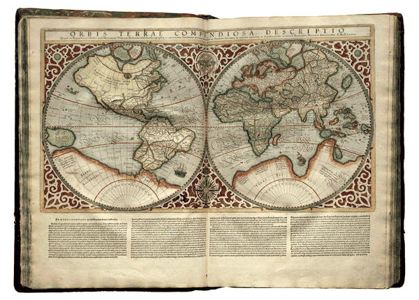
Centuries ago, maps and atlases were deployed to document exploration and expansion. “After a century in which European readers were inundated with accounts of the New World and of the treasures of the Indies,” map curator James Ackerman writes, “they had grown accustomed to and eager for maps of all sorts.”6 By the late sixteenth century, that hunger for maps yielded a new bibliographic form—one that was more than a mere collection of cartography. These atlases, Ackerman argues, were edited and structured collections of maps that took advantage of new printing technologies available at the time to privilege graphic over textual elements and to achieve a “rough uniformity of map format, design, and presentation throughout the work.”7 The geographer-cartographer Gerardus Mercator named the genre after the mythical Titan condemned to hold up the heavens; Mercator’s own atlas would take on no less onerous a task: “I shall lay out the whole world as though in a mirror, so that there shall be certain rudiments for finding the causes of things and attaining wisdom and prudence.”8 The colonial expansion documented and facilitated by these new atlases launched programs of extraction and industrialization that precipitated the myriad forms of loss—of species, cultures, and terrains—that nineteenth-century media would then seek to preserve.
Yet artists, designers, geographers, and climate activists have wielded atlases to play a protective role, too. How might the atlas—obviously not a new media form but certainly one that can be reimagined for the Anthropocene—serve today to capture and preserve the world’s “vanishing” (or intentionally “vanished”) landforms, life-forms, and languages before they, too, disappear? As these atlases serve to help us chart out and prepare for a precarious future, how might we learn from historical instances of geographic uncertainty and epistemological precarity? And how might contemporary countermapping practices and non-Western cartographic traditions point the way beyond precarity to new ways of living in relation to the Land we inhabit?
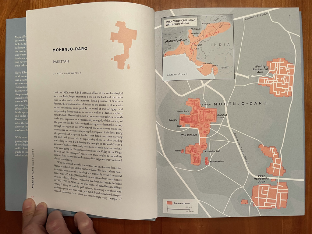
In their Atlas of Vanishing Places: The Lost Worlds As They Were and As They Are Now, Travis Elborough and Martin Brown acknowledge that, over the millennia—starting well before the age of climate change—scores of cities and civilizations have disappeared from the earth.9 Mohenjo-Daro, Hattusa, Xanadu, Palenque, Petra, Chanchan, Roanoke Colony: “in some instances,” the authors write, “the charts are all that remain of the territories, their precise coordinates no longer mapping onto any recognizable part of the world today.” Maps of the lost can serve as “a means for mourning,” a tool for remembrance—and a reminder of the volatility of settlements and states and the terrestrial grounds they claim.10 That fragility is ever more apparent today, as we recognize that the legacies of imperialism and colonialism include increased climatic and, thus, geographic volatility. As digital humanities scholar James Lee writes, “Climate was the spatial blueprint” upon which some Renaissance-era imperial forces “built colonial trade and its outposts—purposefully, along latitude bands, where living things could be easily exchanged… [T]he global movement of life that triggered a global drop in carbon dioxide identified by scientists at the time was not a byproduct of colonialism. It was the motivation for colonialism itself.”11
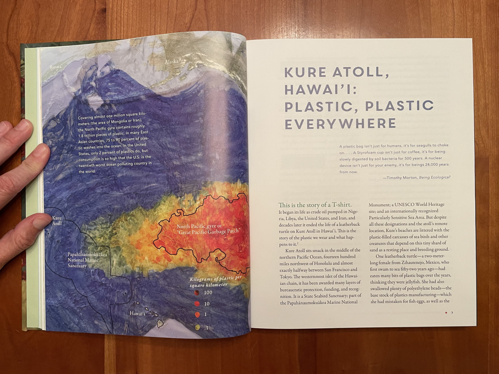
In The Atlas of Disappearing Places, Christina Conklin and Marina Psaros document twenty sites affected by climate change—from Kure Atoll in Hawai‘i to Kutupalong Camp in Bangladesh, from the Pine Island Glacier in Antarctica to New York City—and render each in water-soluble inks on a single, 150-square-foot piece of dried “sea lettuce.” These materials yield a map as precarious as the terrains they represent. As the authors explain, “If water touches the ink, it will wash away. If the parchment gets wet, it will instantly reanimate into slippery, slimy sheets, and the map is gone.”12 The book progresses from “changing chemistry,” which engages with our reliance on fossil fuels, to “strengthening storms” to “warming waters” to “rising seas.” Each chapter, illustrated with Conklin’s maps, describes the particular climate context—historical environmental injustices, recent disasters, relevant design projects and legislation, and so forth—of a single city. It then closes with a speculative vision of how that city might fare in 2050, after suffering additional climate disasters and implementing a mix of technological and policy interventions. The atlas’s impressionistic maps welcome the projection of multiple temporalities—the city as it is today, as a product of historical forces and contemporary policies and practices, and the city as it could be at mid-century. This atlas invites us to inhabit a heterotopia, seeing places both as they are now and as they might be otherwise.
Christina Gerhardt’s forthcoming Atlas of (Remote) Islands and Sea Level Rise focuses on low-lying lands that are particularly vulnerable to climate change despite their own comparatively minuscule contribution to the forces effecting that change. Drawing formal and graphic inspiration from Judith Schalansky’s award-winning Atlas of Remote Islands: Fifty Islands I Have Never Set Foot On and Never Will, Gerhardt’s book will feature, on each spread, a map of an island or island group; visualizations of the island’s sea level today and in 2050 and 2100; geographic data about each island; demographic data about its Indigenous inhabitants; a timeline of Indigenous, “pre-contact,” and climate-related histories; and an essay on the island and its inhabitants. Each narrative will depict various “solutions” deployed both by global and national governments and by Indigenous peoples: from sea walls and geoengineering to preserving and restoring coral and oyster reefs, mangrove marshes, wetlands, and other natural buffers.13 Gerhardt explains: “I’m trying to smuggle politics to people through a coffee table book.”14
Low-lying islands are indeed charismatic figures—photogenic ambassadors—in the mediation of climate change. Yet, as Dan Nosowitz argues in Atlas Obscura, they’re also inherently dynamic, ephemeral landforms: “barrier islands are basically perpetually rolling over, and sometimes disappear and reappear, or split in two, or migrate up a coast.”15 They’re subject to the vagaries of tectonic shifts and tides. This is also, and especially, true of many atolls, which lie within the South Pacific Convergence Zone, an exceptionally volatile environment where winds from two regions collide, creating powerful wind and rain. Thus, while these landforms are defined by their volatility—their periodic disappearance and reemergence—they still represent extreme cases of anthropocenic effects: “small changes will make an oversize impact there,” which is conducive to mediated representation. Aerial imagery will readily reveal dramatic changes to their coastlines, and photographs will spectacularize their submerged infrastructures.
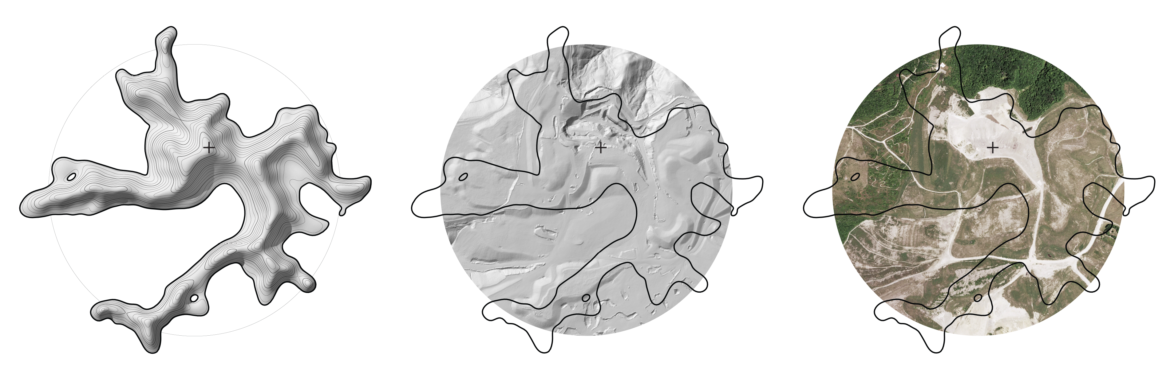
We might regard the archive as an epistemological cousin to the atlas. Architect Brent Sturlaugson’s “Archive of Lost Mountains” documents the mountaintops lost to coal mining in Appalachia. Explosives, draglines, and dozers have shorn these hills of their crowns, which are not only ontologically disappeared, but they’re epistemologically erased too. As Sturlaugson explains, “the mountaintops remain lost to the state sanctioned recordkeepers of topographic information.”16 USGS maps fail to keep up with the transformations. The mountains transform faster than the media that document them. To trace this ghost geology, Sturlaugson looks for topographical anomalies: plateaus at high elevations, which are not naturally occurring in this region. He then cross-references multiple data sets with historic topographic maps, conducts slope analyses, and creates digital models of the pre- and post-mining landforms. To frame these anthropocenic interventions as violent and their effects as scars, he produces maps that render the plateaus in high contrast, and he creates physical models in exaggerated heights, materialized in concrete flecked with fly ash remains. Like Conklin’s algae maps, Sturlaugson’s models carry physical traces of the hills they represent. These drawings and models are supplemented with historical data—including information about the mining companies and their operations—and will eventually include oral histories from Appalachians who can speak to their memories of these lost lands. This assemblage of atlases deploys various media forms and graphic treatments to convey loss, to identify historical destructive forces and new threats, to suggest what it means to vanish. Some give voice to local communities grappling with environmental destruction, yet all seem committed to providing cartographic tools to both those local communities and a global readership in order to prepare everyone for the difficult, systemic work of ecological preservation.
Vanishing as Un-Knowing
The history of cartography is filled with appearing and disappearing landforms. Their vanishing isn’t merely a physical or ontological phenomenon; it’s about epistemology and mediation, too. Evolving geographical knowledge, new navigational instruments, new documentation tools, new printing technologies, new imaging tools and geographic information systems have made possible the “discovery,” verification, and representation of new lands—or the erasure of those lands that proved illusory and erroneous. Consider the legacy of phantom islands: landforms that have long been the subjects of myth and superstition, the accidental products of navigational imprecision and perceptual errors: icebergs and low-lying clouds or fog banks mistaken for land, mirages distorting the seascape. As Malachy Tallack and Katie Scott write in The Undiscovered Islands: An Archipelago of Myths and Mysteries, Phantoms and Fakes, the Arctic and Antarctic have historically been particularly epistemologically unstable terrain: they’re the most difficult regions to reach, among the last to be explored, and the most prone to illusions like fata morgana and island-sized icebergs.17

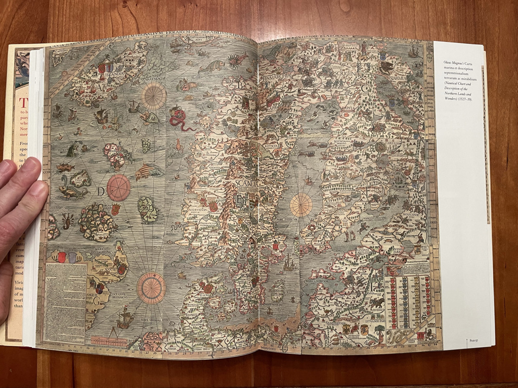
Many illusory islands are the result of “honest error,” Edward Brooke-Hitching writes in The Phantom Atlas: The Greatest Myths, Lies and Blunders on Maps. Such mistakes are “rooted in educated guesses of ‘wishful mapping’ or the limited ability of contemporary measurement systems. Coordinates were rough and imprecise, until John Harrison’s invention of an accurate marine chronometer in the eighteenth century provided a long-sought solution to the problem of measuring longitude.”18 Inaccuracies were reiterated on copied manuscripts and propagated far and wide through printed atlases. The perceived authority and veracity of print made a fallacious geographical claim especially difficult to refute. The cartographer’s corrective and the printer’s press couldn’t move any faster than the ships that delivered their geographic content: “While a single source could announce the discovery of new lands,” Tallack and Scott write, “it would usually take several non-sightings to confirm the falsity of that source.”19
Geography was also, occasionally, the result of “innocent” fabulation or entrepreneurial speculation. Tallack and Scott propose that some geographical inventions, like many other untruths, were a compensatory practice: “Absence is terrifying, and so we fill the gaps in our knowledge with invented things,” whether islands or utopias or underworlds or sea monsters.20 Brooke-Hitching introduces us to Don Pedro de Sarmiento, who explained that a particular island depicted on a map of the Strait of Gibraltar was “to be called Painters’ Wife’s Island”: “while the painter drew that map, his wife sitting by desired him to put in one country for her, that she in her imagination might have an Island of her own… I fear the painter’s wife hath many Islands and some countries, too, upon the continent in our common maps, which are not really to be found on the strictest search.”21
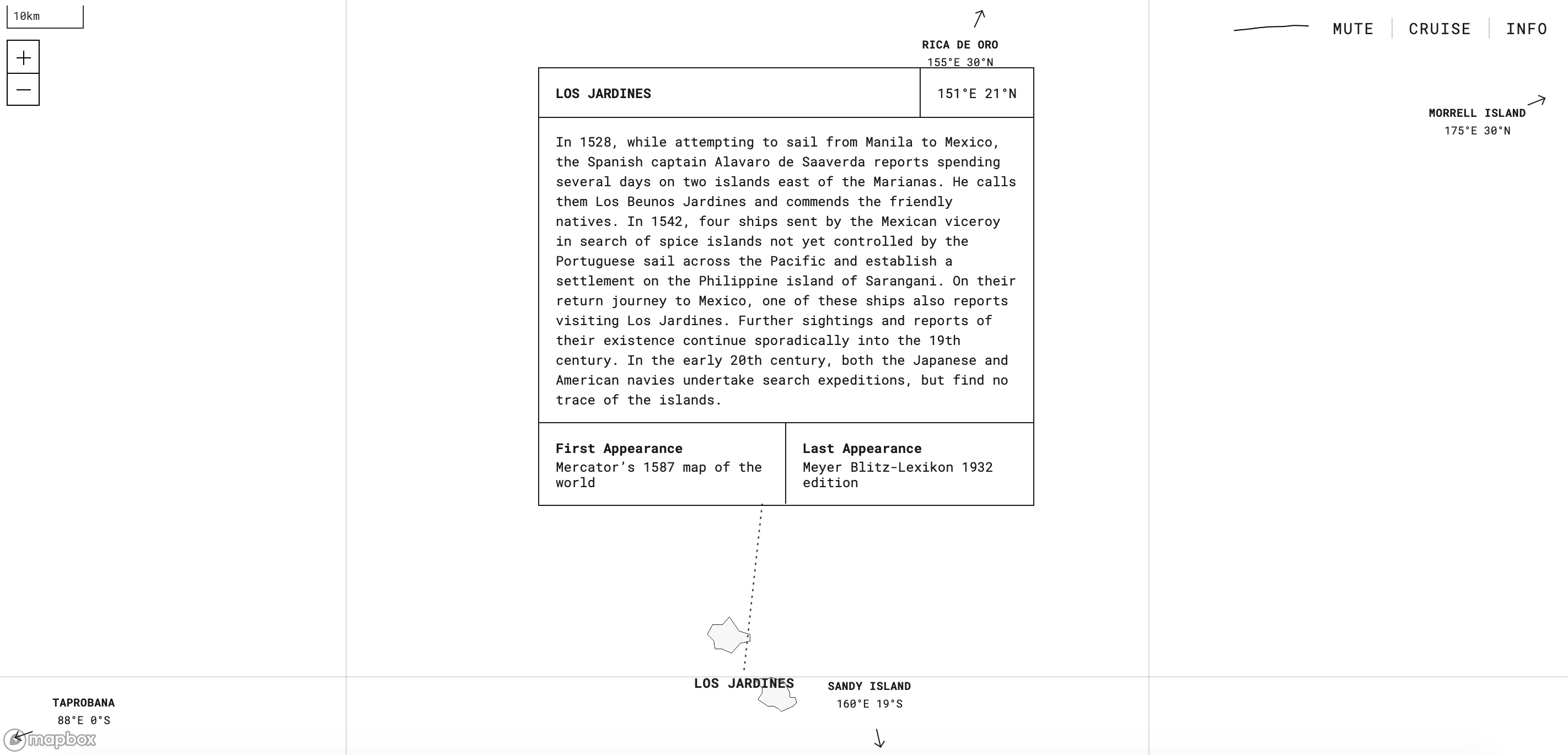
Some speculators and scoundrels—Benjamin Morrell and Gregor MacGregor were among the most notorious—invented landforms not to appease their spouses but to win fame and fortune. “Wild tales sold books and earned popularity. Adventurers cast themselves in heroic light, seducing funds from backers for future expeditions.”22 Keeping the slowness of geographical corrections in mind, Tallack and Scott note that it took more than a decade to realize that Byers Island and Morrell Island, around which the International Date Line was drawn in 1884, were Morrell myths from 1825.23
Some fabrications were a matter of geopolitical subterfuge. Forgeries occasionally served the purpose of establishing nationalist claims to terrains, suggesting that explorers preceded Indigenous populations. Tallack and Scott include in their atlas Hy Brasil, a mythical island west of Ireland. “There is good evidence to suggest that sailors in the late 15th century were using Brasil as a codeword” for North America, they argue. “Their secrecy was a means of concealing knowledge from other European powers, not just about the land itself, but about the extraordinarily rich fishery off the coast of Newfoundland.”24 As geographic knowledge became not only a matter of national security and power but also a matter of intellectual property, cartographers inserted fabulated geographies to mark their work: they “indulged,” and still do, “in minor deceptions for protection, devising their own fictitious geographies to use as copyright ‘traps.’”25
Islands as Datalogical Phantoms
Artists Andrew Pekler, Flavio Gortana, and Kiwi Menrath have also recently engaged in their own “minor [cartographic] deceptions”—not to stake their claim to geographical knowledge but to amplify the historical, political, and epistemological contexts through which much of that knowledge has been generated. Their 2018 “Phantom Islands – A Sonic Atlas” uses a clean, clinical base map to chart the sounds of various historical phantom islands, which Pekler likens to “hallucinations brought on by the high fever of European expansionism and colonialist ambitions.”26 "Phantom Islands" is a fever dream rendered in starkly objective black and white. Nodding to the work of nineteenth-century salvation ethnographers, Pekler uses electronic instruments to create sounds that evoke archipelagic flora and fauna and “elements that are reminiscent of ethnographic recordings.”27 A cross between field recordings and synthetic compositions, his soundscapes reflect the ontological ambiguity of phantom islands themselves, the artist told critic Régine Debatty. His experimentation with non-Western musical tropes, or musical “exotica,” also allows the project to “methodically exoticize non-existent places in order to make visible the process of exoticization itself.” "Phantom Islands" is the product of an “imaginary ethnography”—one based on fictitious places once believed to be real—that helps us see and hear “how all exoticas are fictions.”28
On the spectrum of geographical fabrication, fiction is perhaps a few degrees away from error. Yet even as we’ve purportedly graduated from analog to digital maps and supplanted the explorer’s entrepreneurial eye with the seemingly impartial gaze of satellites and global positioning systems, we still encounter islands of error. Null Island, which lies at the confluence of the equator and the prime meridian (zero degrees latitude, zero degrees longitude), was imagined as a spatio-technical corral for geocoding errors—that is, mistakes that arise when addresses are converted into latitude and longitude coordinates. These errors can result from typos, messy data, or technical glitches—or perhaps even GPS spoofing.29 An invalid address might be erroneously coded as 0,0—which is, of course, an actual place on the Earth. Lots of technical mistakes live here. A website for the fictional Republic of Null Island describes its history, geography, people, economy, and opportunities for travel.30 In a comment on the Library of Congress’s geography blog, Kevin S. describes his passage through Null Island in 2007,
As we approached this mystical point in the ocean in the middle of the night, I was surprised to see DOZENS of vessels there on my AIS (Automatic Identification System) display. I was looking with my own eyes and didn’t see the lights from any ships, so I didn’t understand at first why this party of ships was supposedly happening at 0N/0E. As I continued to watch, I noticed ships kept popping up there (on the AIS display)… and then disappearing. New ships kept popping up there… and then disappearing. It finally dawned on us that anytime someone in Los Angeles or Hong Kong or Dubai or anywhere else in the world first turned on their AIS system, before it obtained its first GPS fix, it defaulted to reporting its position as “00-00N / 00-00E” and showed up on our AIS display in the Gulf of Guinea. After they got a GPS fix, their position suddenly updated to wherever they really were in the world and disappeared from the Gulf of Guinea. It was a pretty interesting phenomenon to watch.
Null Island is conjured up on situated screens, as they float through a convergence point on the global grid and register the waking-up of other screens in far-flung locations. As the Library of Congress’s Tim St. Onge poignantly explains, Null Island “is a curious blend of real and imaginary geography, of mathematical certainty and pure fantasy.”31
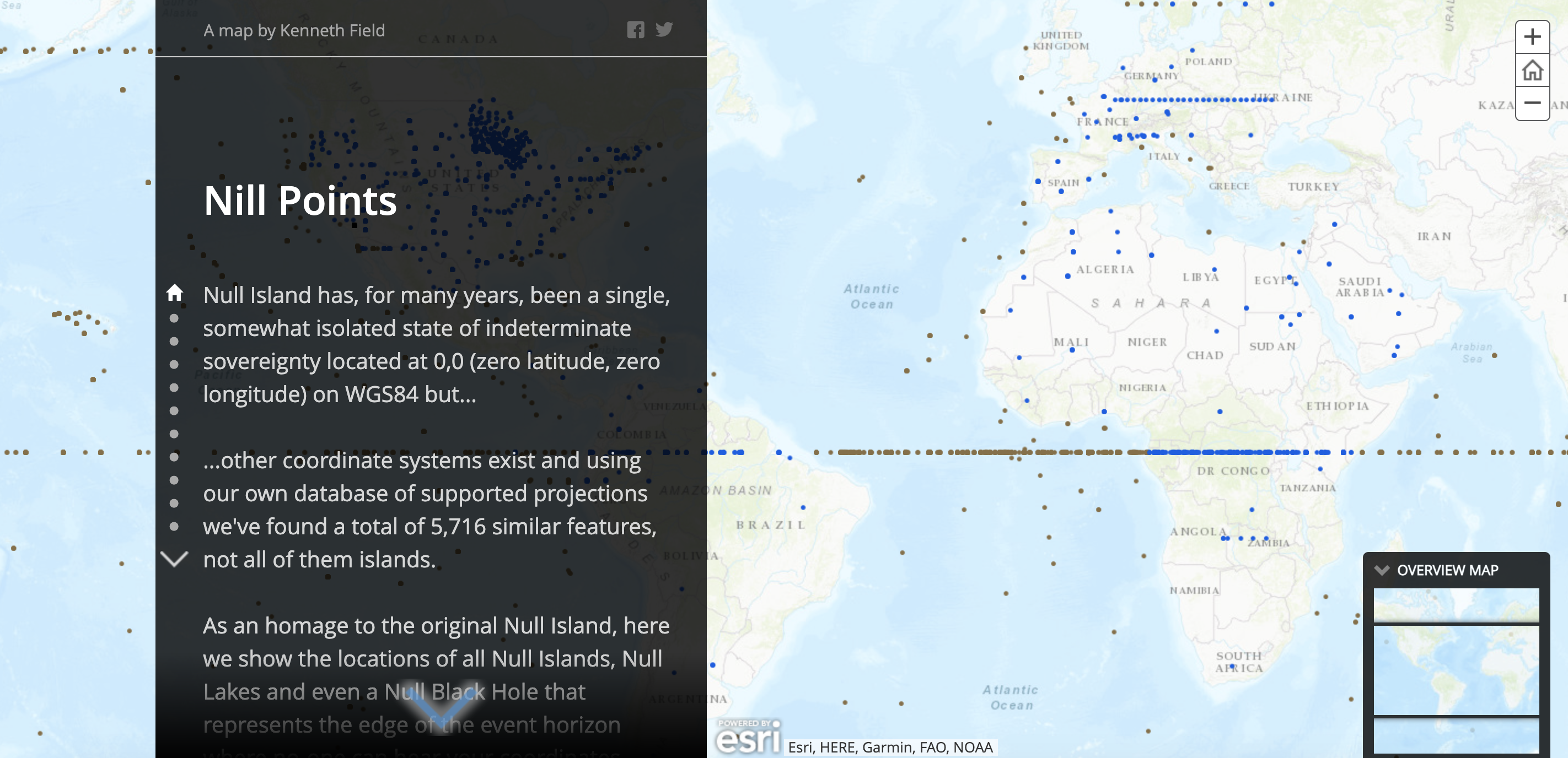
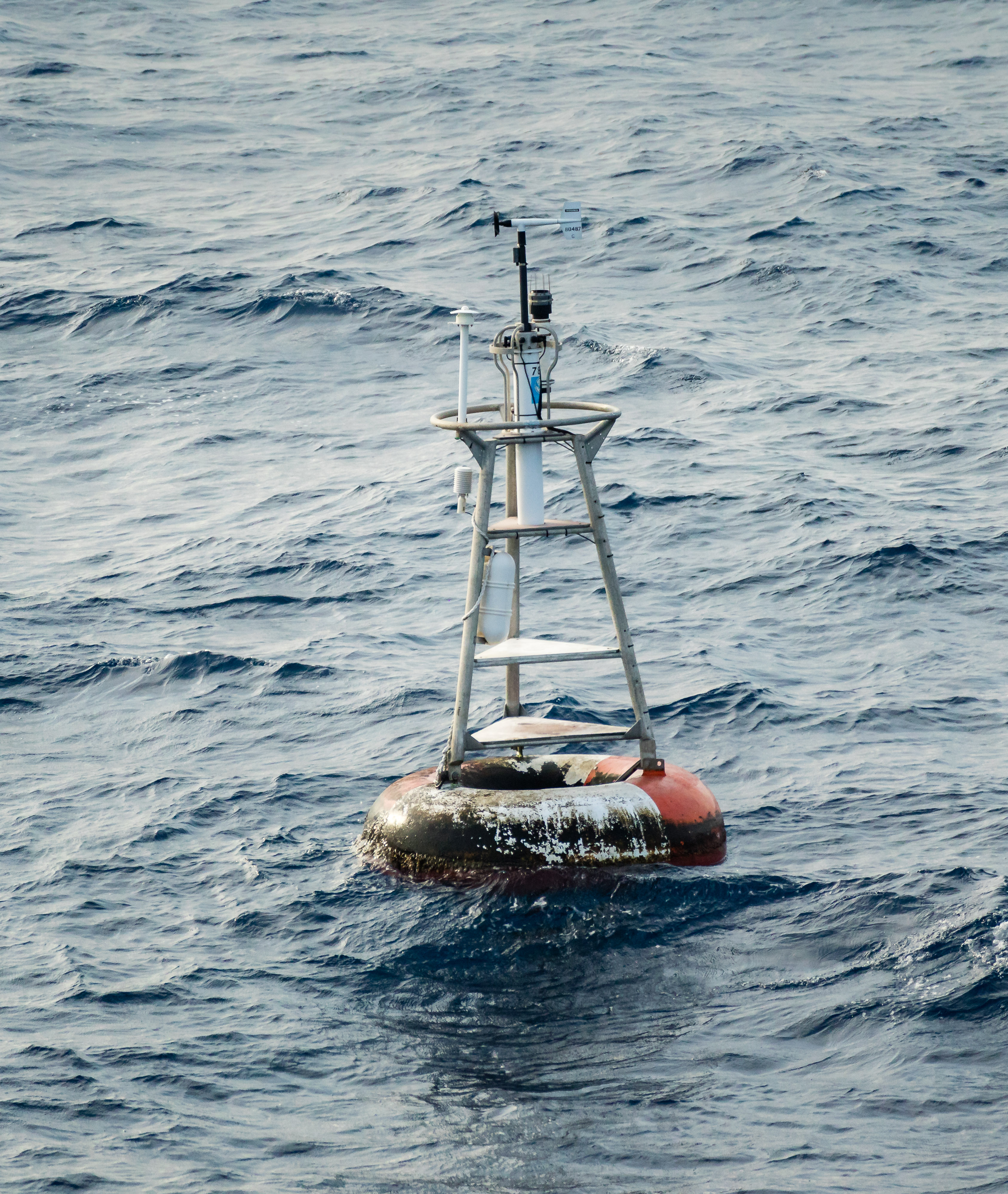
Yet this spot of ocean off the west coast of Africa isn’t the only “island of misfit data.” Surveying a variety of map coordinates and projection systems, cartographer Kenneth Field produced an atlas (of sorts) featuring over 5,700 additional “nill points,” including other islands and lakes—and even a black hole.32 Null Island might be a metaphorical black hole of geocoding glitches—but it is also, paradoxically, a physical site that supports the creation of data about material environments. At 0,0 sits Station 13010 (aka “Soul”), a National Oceanic and Atmospheric Association weather observation buoy. It’s got a Twitter account. Here, within this datalogical island where geocoding errors flash and disappear, a physical apparatus produces data that could, ultimately, contribute to the preservation of all those low-lying islands and precarious landscapes.
Mapping Abundance
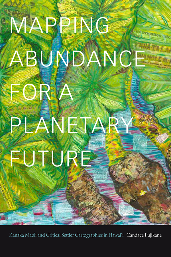
Yet all the datasets and geospatial technologies in the world can’t disabuse us—and by us, I mean much of the Global North—of a persistent, pernicious cartographic fiction: the source of scarcity itself. In reality, capitalist models of the world that depict scarcity and depletion are made to produce markets. Cartographies of capital, Candace Fujikane argues, are based on logics of enclosure and extraction and domestication; they “commodify and diminish the vitality of land by drawing boundary lines around successively smaller, isolated pieces of land that capital proclaims are no longer ‘culturally significant’ or ‘agriculturally feasible,’ often portraying abundant lands as wastelands incapable of sustaining life.”33 Capital thrives on islands of precarity; its atlases don’t merely “depict the symptoms of a planet laid waste by late liberal settler states and globalization, but are themselves a primary driving force of climate change.”34
Fujikane describes how, roughly a decade ago, developers aimed to reclassify nearly a hundred acres along the Wai‘anae coast from agricultural to urban land in order to justify its development as an industrial park. They marshaled maps as media coverage that depicted the land as “arid wastelands, both geographically and culturally, racialized as Hawaiian places of poverty, houselessness, substance abuse, and violence.”35 For over a century, settler colonialism and global capital had effected similar slow erasures: “many people in Hawai‘i have grown alienated from living lands, the wahi pana (celebrated places) and wahi kapu (sacred places) that have over time become commodified and urbanized.”36 Traditional place names, which crystallized the landscape’s riches, have likewise been supplanted. And the Army Corps of Engineers, through its decades of interventions, physically erased streams and marshlands and indigenous flora.
Yet in an act of what we might call “salvage counter-cartography,” local environmental activists deployed a traditional spatial practice, hauka’i, the embodied journey. They invited decision makers to travel the land and see its wonder for themselves on a Huaka’i Kāko’o no Wai‘anae Environmental Justice bus tour.37 The tour guides’ narration wove together the childhood memories of people who grew up in the Lualualei Valley; histories of toxic waste dumping; descriptions of the processes of extractivism authorized by the city, county, and the occupying state; and celebrations of community-based organizing and the “vitality of the mo’olelo” (storied history). Their recovery of traditional genealogies and ontologies of the land is part of what Fujikane calls the “radical resurgence of Kanaka Maoli ways of knowing, along with the critical decolonial effects they create as they illustrate that what the occupying state designates as wastelands are actually ‘āina momona (fat, fertile, abundant lands) and ‘āina kamaha’o (wondrous lands).”
Maps informed by Indigenous knowledges portray the world as a place of plenty and invite us to conserve and enhance that abundance. “Rather than seeing climate change as apocalyptic,” Fujikane writes, “we can see that climate change is bringing about the demise of capital, making way for Indigenous lifeways that center familial relationships with the earth and elemental forms.” Indigenous atlases of abundance map out a future that will enable Indigenous lifeways “to survive what capital cannot.”38 These atlases do not foreground the vanishing—or presume that merely documenting the devastation constitutes sufficient political action. They instead “approach what appear to be the precarities of climate change and… ground those changes in observable data regarding the interconnection of moon phases with the growth of plants, the spawning of fish, coral, and shellfish, the propagation of limu (seaweed), the patterns of winds, rains, and stream and ocean currents”—not for the purposes of extraction but in order to understand their interconnection.39 Rather than framing “adaptation as resignation,” atlases of abundance frame adaptation as an “active analytic that enables us to anticipate change[s] and to act to maximize their potentially abundant effects.”40 When we see the world as terrain to capture and resources to extract, our maps portray it as a site of scarcity and loss. With traditional Kanaka Maoli and other contemporary Indigenous cartographies and the worldviews they cultivate, what ultimately vanishes might be the very political-economic forces causing planetary destruction.
The author would like to thank Sam Kellogg and Rory Solomon, who organized an “Atlas of Media Topography” workshop at the 2021 Society for Literature, Science, and the Arts conference, where she began developing this essay.
-
I’m grateful to Jon Christensen for this coinage. Twitter, September 6, 2021, link. ↩
-
See, for instance, Aleida Assmann, Cultural Memory and Western Civilization: Arts of Memory (Cambridge University Press, 1997); Sabrina Hughes, “Imag(in)ing Paris for Posterity,” Future Anterior 10, no. 2 (2013): 1–15; Tamara Kneese, “Digital Afterlives: From the Electronic Village to the Networked Estate,” Dissertation, New York University, 2016; Brian Michael Murphy, We the Dead: Preserving Data at the End of the World (University of North Carolina Press, forthcoming 2022); Shelley Rice, Parisian Views (MIT Press, 1999); Jeffrey Sconce, Haunted Media: Electronic Presence from Telegraphy to Television (Duke University Press, 2020); Jonathan Sterne, The Audible Past: Cultural Origins of Sound Reproduction (Duke University Press, 2003); Sarah Wasserman, The Death of Things: Ephemera and the American Novel (University of Minnesota Press, 2020). ↩
-
Brian Hochman, Savage Preservation: The Ethnographic Origins of Modern Media Technology (University of Minnesota Press, 2014), xiii. ↩
-
Joel Chadabe, “Ear to the Earth: It Started in the Dark,” érudit, September 9, 2015, link. ↩
-
“Disappearing Species: Suspended Sounds,” Ear to the Earth, link. See also Sari Carel’s Semaphore Island: link. ↩
-
James R. Ackerman, “From Book with Maps to Books As Map: The Editor in the Creation of the Atlas Idea,” in Joan Winearls, Editing Early and Historical Atlases (University of Toronto Press, 1995), 35. ↩
-
Ackerman, “From Book with Maps to Books As Map,” 4. ↩
-
Gerardus Mercator, Atlas sive Cosmographicae Meditationes de Fabrica Mundi et Fabricati Figura, trans. David Sullivan (Lessing J. Rosenwald Collection, Library of Congress / Octavo, 2000), link. ↩
-
Travis Elborough and Martin Brown, Atlas of Vanishing Places: The Lost Worlds As They Were and As They Are Now (White Lion, 2019). ↩
-
Elborough and Brown, Atlas of Vanishing Places, 9. ↩
-
James Lee, “Opening the Anthropocene Archives,” Public Books, February 8, 2021, link. ↩
-
Christina Conklin and Marina Psaros, The Atlas of Disappearing Places: Our Coasts and Oceans in the Climate Crisis (New Press, 2021), xii. ↩
-
“Christina Gerhardt: Atlas of (Remote) Islands and Sea Level Rise,” University of Minnesota Institute for Advanced Study (2018), link; Morgan Kelly, “Christina Gerhardt, 2021 Barron Visiting Professor, Studies How Sea-Level Rise Influences Culture,” High Meadows Environmental Institute, September 1, 2021, link; Judith Schalansky, Atlas of Remote Islands: Fifty Islands I Have Never Set Foot On and Never Will (Penguin, 2010). ↩
-
Kelly, "Christina Gerhardt." ↩
-
Dan Nosowitz, “How Alarming Is It that Islands Are Just Disappearing?” Atlas Obscura, March 27, 2019, link. ↩
-
Brent Sturlaugson, “Archive of Lost Mountains,” ASCA Annual Meeting (2021): 3. For more on the "Archive of Lost Mountains" project see: link. ↩
-
Malachy Tallack and Katie Scott, The Undiscovered Islands: An Archipelago of Myths and Mysteries, Phantoms and Fakes (Picador, 2016), 121. ↩
-
Edward Brooke-Hitching, The Phantom Atlas: The Greatest Myths, Lies and Blunders on Maps (Chronicle Books, 2018), 10. ↩
-
Tallack and Scott, The Undiscovered Islands, 55. ↩
-
Tallack and Scott, The Undiscovered Islands, 11. ↩
-
Benjamin Franklin Ellis, ed., “Remarkable Travels” in Western Miscellany 2 (July 1843 to July 1849): 200. ↩
-
Brooke-Hitching, The Phantom Atlas, 11. ↩
-
Tallack and Scott, The Undiscovered Islands, 99. See also Avraham Ariel and Nora Ariel Berge, Plotting the Globe: Stories of Meridians, Parallels, and the International Date Line (Greenwood, 2006), 147; and Grant Hutchinson, “Territories that Crossed the Date Line: Part 1 – Up to 1900,” The Okiofuge, February 21, 2018, link. ↩
-
Tallack and Scott, The Undiscovered Islands, 58. ↩
-
Brooke-Hitching, The Phantom Atlas, 11. ↩
-
Andrew Pekler, Flavio Gortana, and Kiwi Menrath, Phantom Islands – A Sonic Atlas, link. ↩
-
Régine Debatty, “Phatom Islands – A Sonic Atlas,” We Make Money Not Art, August 14, 2018, link. ↩
-
Debatty, “Phatom Islands – A Sonic Atlas.” ↩
-
Frank Jacobs, “Mystery Unsolved: Ghost Ships Circling Off California,” Big Think, March 18, 2021, link. ↩
-
The Republic of Null Island: link. See also Sofia Belenky, Null Island, Intermediate 5 unit, Architectural Association, London, 2017 in Ryan Dillon, “Zero Zero Ze(r)ro(r): How the Cartographic Thirst to Project the Real Reveals Spaces for the Creation of New Worlds,” Architectural Design 91, no. 3 (2021), link. ↩
-
Tim St. Onge, “The Geographical Oddity of Null Island,” Worlds Revealed: Geography & Maps at the Library of Congress, April 22, 2016, link. ↩
-
Kenneth Field, “Nill Points,” link. The Los Angeles Police Department’s crime map once gathered all mis-coded locations on the 200 block of West First Street, which meant that in a six-month period between fall 2008 and spring 2009, that single block ostensibly hosted nearly 1,400 crimes—or roughly eight per day. Ben Welsh and Doug Smith, “Highest Crime Rate in LA? No, Just an LAPD Map Glitch,” Los Angeles Times, April 5, 2009, link. ↩
-
Candace Fujikane, Mapping Abundance for a Planetary Future Kanaka Maoli and Critical Settler Cartographies in Hawai‘i (Duke University Press, 2021), 5. ↩
-
Fujikane, Mapping Abundance, 3. ↩
-
Fujikane, Mapping Abundance, 68. ↩
-
Fujikane, Mapping Abundance, 63. ↩
-
The passages in this paragraph are drawn from Fujikane, Mapping Abundance, 62, 63. ↩
-
Fujikane, Mapping Abundance, 3. ↩
-
Fujikane, Mapping Abundance, 28. ↩
-
Fujikane, Mapping Abundance, 26. ↩
Shannon Mattern’s research and teaching focus on media architectures and infrastructures and spatial epistemologies. You can find her at wordsinspace.net.