
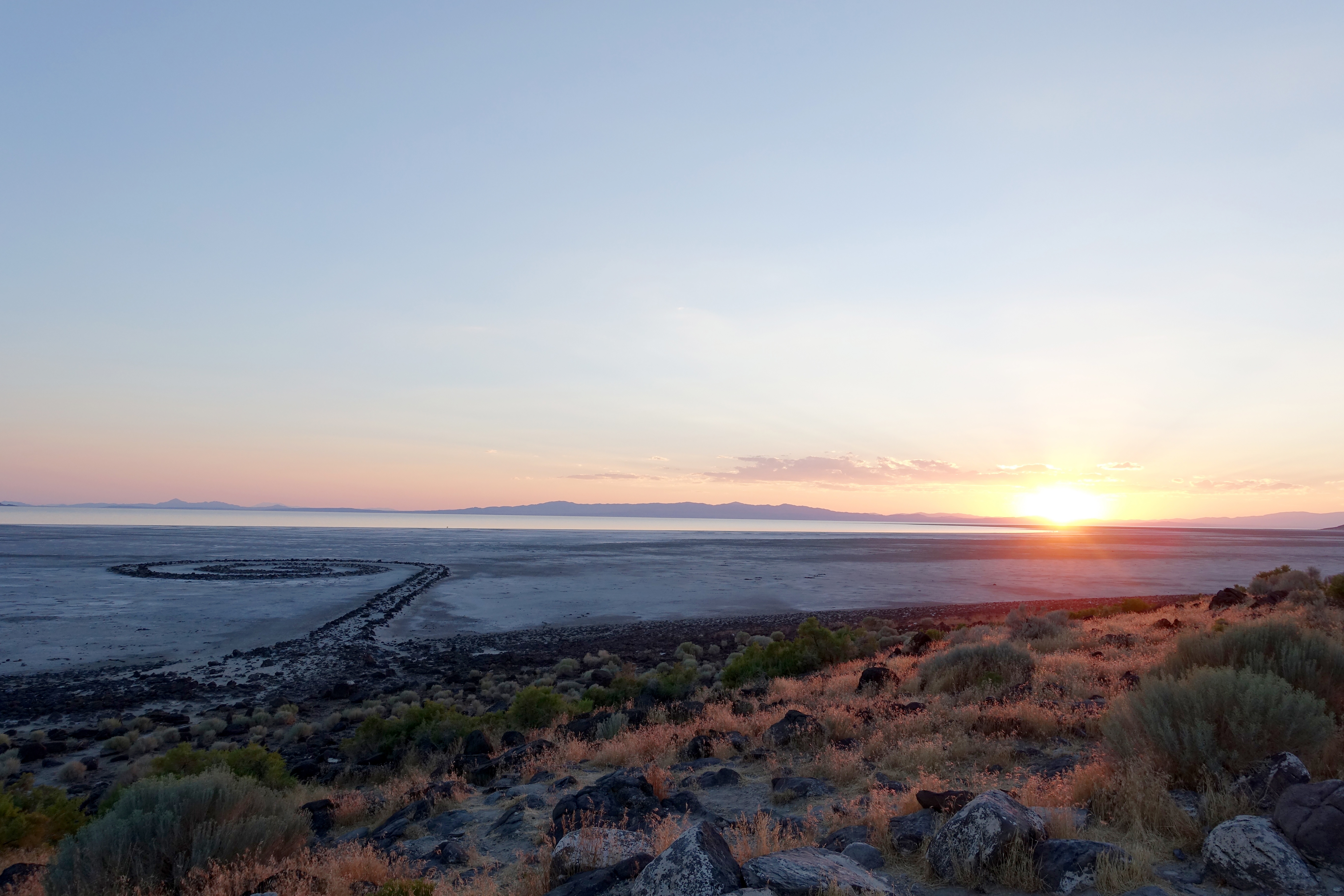
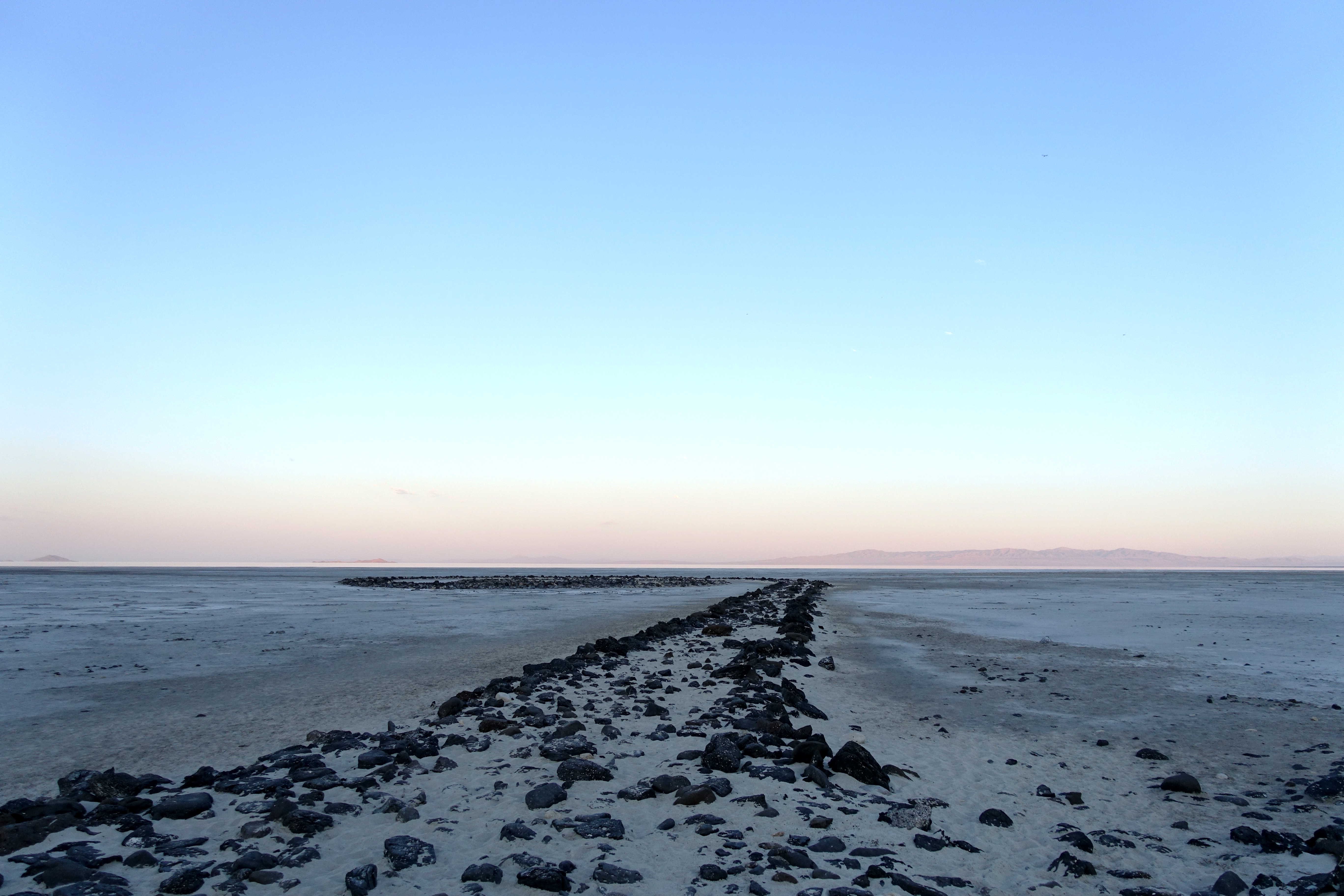
Snaking through the hills on the north shore of the Great Salt Lake, the road to Spiral Jetty (1969), Robert Smithson’s magnum opus in rock and salt, is long, dusty, and—aside from the rumbling of the car over gravel—pleasantly quiet. The area is crisscrossed by dirt roads cutting through old ranches, abandoned towns, and seemingly endless expanses of sparsely populated land.
Directions to the Jetty are provided by the Dia Art Foundation website. The foundation acquired the work from Nancy Holt and the estate of Robert Smithson in 1999 and have managed it ever since, including the addition of a small commemorative plaque overlooking the earthwork and the installation of a campground for visitors wishing to stay the night. Dia’s directions are clear enough, and the route is well marked by signs, gently pulling you toward the Spiral as you travel through the desert. Included in the directions are notes about the “LAST GAS STATION” in Corinne Utah, 41 miles to the east, and the “LAST BATHROOMS” and “LAST CELL RECEPTION” at the Golden Spike Historic Site, a small yet well-staffed national monument commemorating the exact location where the east- and west-coast railroad lines were hammered together with a solid gold railroad spike.1
Following directions printed from a website seems almost quaint in the age of Google Maps and cheap GPS devices, with the road signs reading more like warnings than travel tips. Clearly being stranded without gas and toilets is now on par with being without cell reception, or even worse, without an Internet connection. Up until the exact moment cell reception cut out, our trip had been constantly marked in both time and space by the small blue orb pointing my phone, car, and thus body toward our destination, marking us, in real time, within the vast cartographic empire of Google Maps.
Google Maps went live in February 2005.2 Within a year it was available for cell phone use, and Google quickly tied satellite imagery to its vector-based maps, launching Google Earth, a stand-alone computer program that “lets you take a virtual journey to any location in the world.”3 Between the two applications, users are able to access a vast array of geospatial information anywhere with an internet connection. Integrating social media platforms and photo uploading technologies, Google provides a multi-axis, multiscale, and multiperspective image of the entire planet. Jody Berland proposes the maps accessed through applications like those provided by Google are a “technoterritory as much as they are maps of geophysical terrain.” That is, they are a hyperconnected assemblage of digital information and geospatial technologies that can reveal much more than abstract cartographical detail.4 Entering the Google interface is like delving into Borges’s “Unconscionable Maps,” with the cartographers of Mountain View having figured out how to collapse an entire Empire into the palm of your hand.5
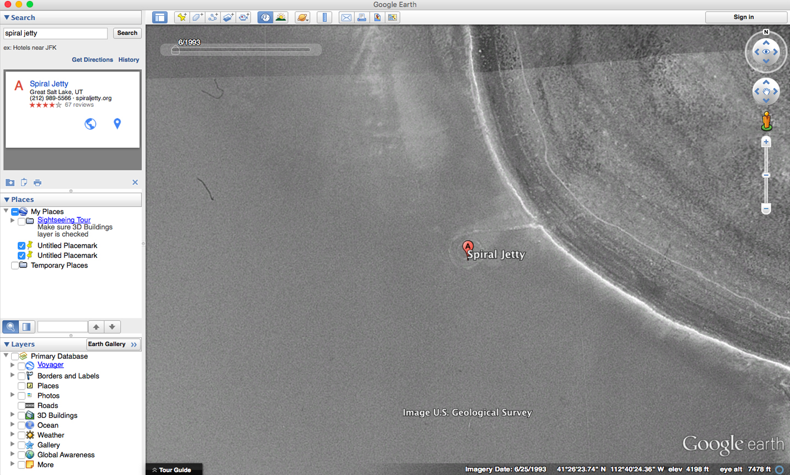
It is easy to forget that the remote sensing technologies making consumer satellite images so pervasive have only been in widespread use for twenty-five years. Lisa Parks notes that the first time a satellite image aired on television was in 1989 when ABC News broadcast an aerial image of a Libyan chemical factory.6 Since then, governments and private companies have launched dozens of satellites into orbit for surveillance, weather, telecommunications, and consumer applications. Google uses multiple sources—from the MODIS Satellite, put into orbit by NASA, to GeoEye and DigitalGlobe, both privately operated, to other sources such as balloons and kites—to stitch together its image of the earth.7 This allows Google to both update their applications in near real time and to maintain a robust archive of geospatial satellite images—a type of low-resolution photo record of the earth’s surface. Images for the Spiral Jetty go back to June 1993, when the Jetty appears to be submerged under saltwater, and Dia’s parking lot and campground have yet to be installed.
In her oft-quoted 1979 essay “Sculpture in the Expanded Field,” Rosalind Krauss designates the Spiral Jetty as a “marked site,” meaning it sits in the expanded field of artistic production beyond and between the categories of “landscape” and “not-landscape.”8 Like other so-called marked sites, the Jetty is an operation upon the landscape and uses materials from it, but it is not what might be called “natural.” In a time when artists like Smithson were taking artistic practice far beyond the spatial confines of the museum and the disciplinary confines of practice, Krauss recognized that such new forms of artistic output were “no longer organized around the definition of a given medium on the grounds of material, or, for that matter, the perception of material.”9 Within this broad view of artistic production, the mediatic apparatuses required to consume so-called land art would therefore also be enveloped in Krauss’s newly conceived definition of sculptural practice.
The status of the image as integral to land art, earthworks, and other works of art not easily accessible for average viewers was not unrecognized before Krauss. In 1971, when Gregoire Müller asked Smithson about the importance of photography for works made in the land, he responded, “I think we are actually talking about multiple ways of locating a thing, and one way to locate a thing is to circumscribe it with a photograph. If you are flying over a piece, you can see its whole configuration in a sense contracted down to a photographic scale.” Smithson went on to say, “For me, a photograph acts as a kind of map that tells you where the piece is and I don’t see anything wrong with that … . All we can do is use our orders and systems to investigate them [earthworks], and they generally turn out to be wrong … . What is interesting is how we fail to understand remote things.”10
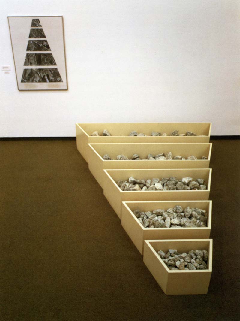
For years preceding Spiral Jetty, Smithson had been productively working in the space between understanding and failure. His Non-Site works combined displaced material from locations in New Jersey with maps of the displacement site. Together the impossible views of the map and the reassembled landscape material sitting next to each other inside the third site of a gallery showed an awareness of the abstraction and possibilities for misunderstanding inherent in mapping as medium. Smithson says he was trying to create a “dialectic of the site and nonsite. The nonsite exists as a kind of deep three-dimensional abstract map that points to a specific site on the surface of the earth. And that’s designated by a kind of mapping procedure. And these places are not destinations; they’re kind of back-waters or fringe areas.”11 Smithson claims the Spiral Jetty is a resolution of the dialectic between site and nonsite, a place where the map and the physical location collapse together into a single site of displaced physical materiality that generates its own mark upon the landscape. Put another way, the Spiral Jetty is incomplete without the map. The spiral, as a form upon the land, is impossible to fully comprehend without its abstracted representation.
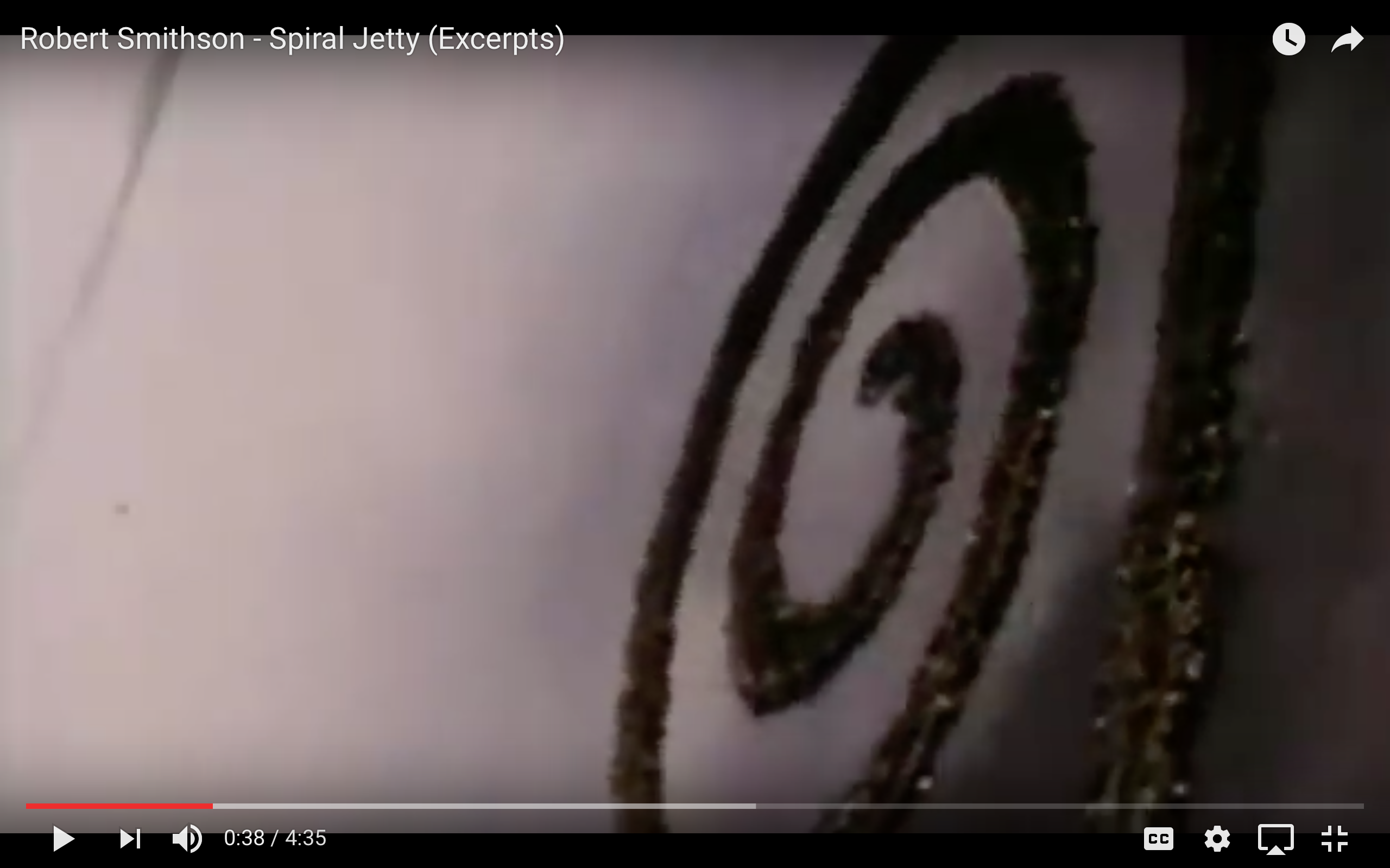
Smithson was keenly aware of the tension his work created by existing as both a mark upon the landscape and its representation in other media. As with many of his other pieces, Smithson made films and photographs about the Spiral Jetty and exhibited them independently as works in their own right. Remarking about the film he made to document the Jetty, Smithson described, in detail, the process for creating the film’s cinematography: “For my film (a film is a spiral made up of frames) I would have myself filmed from a helicopter (from the Greek helix, helikos meaning spiral) directly overhead in order to get the scale in terms of erratic steps.”12 The film is not just documentary evidence of marking the landscape; it exists as one aspect of a broadly conceived work.
The droning repetition of the helicopter blades is heard as the film pans over and around the Jetty. The helicopter dips close to the earthwork and lifts back up, bringing the camera to a nearly vertical, bird’s-eye view, slowly turning, spiral-like, as Smithson speaks over the hum of the machine. He recites his construction details, “North—Mud, salt crystals, rocks, water; North by East—Mud, salt crystals, rocks, water; Northeast by North—Mud, salt crystals, rocks, water … ” as the Jetty is distorted and elongated by the angle of the helicopter, approaching and scanning the work.13
For many of his projects, and his earthworks in particular, Smithson was intensely interested in the idea of entropy, about how a work changes over time, and the unstable relationship between a shifting work and a shifting environment. He recognized entropy as a linear process that could not be reversed. The Spiral Jetty is a work defined by the unknown rigidities of entropic decay.
Smithson claimed he was not interested in large and aggressive interventions into a landscape but in “bringing a landscape with low profile up.” By standing at the end of the Jetty and looking out across the Great Salt Lake, his rather minor adjustments appear as major interventions even as they are dwarfed by a starkly sublime environment. Now over forty years old, it has begun to settle back into the salt plain, the mud and salt and rocks slowly shifting and blurring the once definitive boundaries between ground and that just above. The film, too, is a victim to celluloid decay, and of course, the effects of global climate change on the Jetty and other earthworks throughout the American West are as-of-yet unknown. Standing in stark contrast is the unrelenting digital memory of the Internet, where time can just as easily be played in reverse.
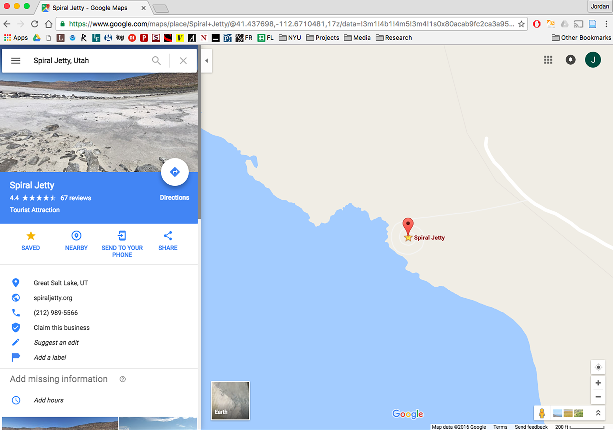
Like many online platforms, Google allows users to tag, rate, and comment on almost anything within the Google Maps environment. The ratings for Spiral Jetty (noted as a “Tourist Attraction”) are 4.4 out of 5. Many users comment on the trip—how far away it is from Salt Lake City, whether the dirt roads are fine or terrible, and whether the journey is worth it or not. On Sites and Non-Sites, Smithson said, “It could be that ‘travel’ in this space is a vast metaphor. Everything between the two sites could become physical metaphorical material devoid of natural meanings and realistic assumptions. Let us say that one goes on a fictitious trip if one decides to go to the site of the Non-Site. The ‘trip’ becomes invented, devised, artificial; therefore, one might call it a non-trip to a site from a Non-site.”14 Each end of the Site/Non-Site dichotomy holds a limited potential for comprehension and understanding. Both stand as abstract demarcations and displacements of material in both time and place that underline the way that knowledge about a place, a work, a landscape, or an action can be understood to be just as illusory as the efforts to represent it.
Google user Alan Rencher’s biting, two-star review of Spiral Jetty suggests, “Look at the aerial picture and save yourself the boring, bumpy ride out to the middle of nowhere to see rocks places [sic] in a circular pattern. Not sure this even qualifies as art.”15 Rencher insists that the work, such as he thinks it is, can be identified and experienced simply through the Google interface. Note that Rencher is not suggesting you ignore the Jetty but that you experience the work through satellite imagery—that looking at it through the digital mediums offered by Google is at least as valid as driving out and seeing it in person from the shore of the Great Salt Lake. Knowing that both methods of viewing the project allow for only an incomplete and abstract understanding, I’d like to think Smithson might just agree with him.
-
Dia Art Foundation, “Robert Smithson, Spiral Jetty,” link. Sadly, the spike itself has been squirreled away in an archive at Stanford University. ↩
-
Google, “Our History in Depth.” ↩
-
Jody Berland, “Mapping Space: Imaging Technologies and the Planetary Body,” in Technoscience and Cyberculture, ed. Stanley Aronowitz, et al. (New York: Routledge, 1996), 125. ↩
-
In this one paragraph story, Jorge Luis Borges wrote of a “Map of the Empire whose size was that of the Empire, and which coincided point for point with it.” See “On Exactitude in Science,” full text available on Wikipedia, link. ↩
-
Lisa Parks, Cultures in Orbit: Satellites and the Televisual (Durham: Duke University Press, 2005), 4. ↩
-
Google Earth Blog, “About Google Earth Imagery,” last modified March 16, 2009, link. ↩
-
Rosalind E. Krauss, “Sculpture in the Expanded Field,” in The Originality of the Avant-Garde and Other Modernist Myths (Cambridge: MIT Press, 1996), 287. ↩
-
Krauss, 289. ↩
-
Quoted in “…The Earth, Subject to Cataclysms is a Cruel Master,” an interview between Gregoire Müller and Robert Smithson in Arts Magazine, 1971, anthologized in Robert Smithson: The Collected Writings, ed. Jack Flam (Berkeley: University of California Press, 1996), 255. ↩
-
“Interview with Robert Smithson for the Archives of American Art/Smithsonian Institution,” in Robert Smithson: The Collected Writings, 295. ↩
-
“The Spiral Jetty,” in Robert Smithson: The Collected Writings, 148. ↩
-
“The Spiral Jetty,” 149. ↩
-
“A Provisional Theory of Non-Sites,” in Robert Smithson: The Collected Writings, 364. ↩
-
Review from Google user Alan Rencher, accessed October 25, 2016, link. ↩
Jordan H. Carver is a writer and sometimes designer based in New York City. He is a contributing editor to the Avery Review and co-organizer of Who Builds Your Architecture? Jordan is currently a Henry M. McCracken Fellow in American Studies at NYU.