
In Palestine, an aerial map is blurred and pixelated, hiding colonial infrastructures of occupation and violence. In the West Bank, a checkpoint set to restrict Palestinian movement closes without warning. In Hebron—Al-Khalil—a house is occupied by Israeli settlers in the middle of the night. These are the infrastructures of settler colonialism at increasingly granular scales, a fast-moving and ongoing Nakba.1 Its violence is mechanized to be brutal, abrupt, and disorienting. It fragments space and hastens the colonial project, erasing the long, slow history that connects people to the land. An act of “dromoelimination” facilitated by settler violence, it “renders Palestinian struggle increasingly vulnerable to [the] accelerating speed of elimination.”2
The sudden home invasions carried out by the Israeli Occupation Forces (IOF) with M16s and M4 machine guns, the unpredictability of artificial intelligence “smart shooter” machine guns set at the Israeli checkpoints,3 the swift closures of those same checkpoints, and the volatility of attacks by Israeli settlers are all strategies that aim to stoke constant anxiety among Palestinian residents and ultimately eliminate Palestinian presence.4 Against this immediacy, other forms of time unfold. In the old city of Hebron, slowness and grounding become tactics of refusal. These acts are not passive principles but rather active resistance that inhabits and refutes the accelerated temporality of occupation. They insist on a different urban rhythm—one of sumud grounded in community, connection, and collective action.
Drawing on my fieldwork, conversations, and observations in Hebron between 2018 and 2022, I reflect on three interrelated practices: the restoration of the Ibrahimi Mosque, my use of charcoal rubbings as a countercartographic practice, and the establishment of the Old Hebron Museum. Together, these sustained actions reveal how Palestinians resist the speed of colonial elimination through alternative temporalities constructed through attentiveness, embodied engagement, and grounded extension beyond the timescale of ruptured violence.
The Marking on the Wall
A bullet hole in Al-Haram Al-Ibrahimi—the Tomb of the Patriarchs—still peeks through a hasty patch job. As both a scar and a small memorial, it offers a keyhole into recent history. More than thirty-one years ago, on February 25, 1994, Palestinian worshippers were at the mosque for their Fajr prayers—especially significant during the holy month of Ramadan. Four minutes into the prayer, at the first kneeling, Baruch Goldstein—an American Israeli settler born in Brooklyn, a doctor with the IOF, and a member of the far-right ultra-Zionist Meir Kahane’s Kach Party—opened fire indiscriminately, wounding 125 and killing 29 of the 800 Muslim worshippers. The massacre was not only an act of spectacular violence but also a temporal rupture. The rapidity of the massacre, compressed into minutes, shattered the collective rhythms of Ramadan and prayer. While the international community and the Israeli state condemned the attack, the Israeli state would still go on to reject the PLO’s request to disarm all Israeli settlers and to implement an international force to protect Palestinians in the West Bank.5
Goldstein’s attack was not isolated. In the twenty-five years preceding the massacre, the Israeli state offered significant support for settler attacks and occupation in Hebron.6 Israeli settlers squatted in the old city, attacked residents, and occupied the lands. The settlements across Hebron began in 1968, a year after the Naksa of 1967, when the Israeli state occupied the West Bank. That year, a group of Israeli civilians, led by Rabbi Moshe Levinger, rented rooms in the Park Hotel for two days to celebrate Passover. The settlers then refused to leave, demanding to stay and create a settlement in the area. Although their act was against official Israeli government policy, the government ultimately backed them, and many ministers visited the settlements in support.7 Soon after, the Israeli cabinet approved the construction of Kiryat Arba, a settlement near Hebron, and later approved the establishment of four more settlements within the old city of Hebron: Avraham Avinu, Beit Hadassah, Beit Romano, and Tel Rumeida. Still today, settlers in Hebron continue to tighten their grip on the city by occupying Palestinians’ houses—some of which have been abandoned due to the occupation’s segregation policies.8 While the massacre was presented to the world as an exception—an immediate, fast, and intense attack—these violent settler assaults are not singular9 but rather an expediting mechanism for colonial incursions and Palestinian elimination.
Immediately after the massacre at Al-Haram, violent clashes broke out between the Palestinian protesters and the IOF, in which six Palestinians in Hebron and five across the occupied territories were killed in what was called the “bloodiest single day since 1967.”10 The massacre inaugurated new draconian measures of control in the West Bank and Gaza, among them a curfew in the main towns that lasted until March 1. In the old city, the IOF placed the Palestinian residents on a 30-day curfew.11 An Israeli commission inquiry into the massacre concluded that, for the sake of “security,” segregation policies must be intensified.12 Under the pretext of safety, the Israeli police established a new station in the old city.13 The Israeli state then closed Al-Haram for ten months. When it reopened, the mosque was partitioned: one section for Muslims, the other for Jews, with separate entrances.14 Palestinians who once had access to the entire site were allowed to access only about 40 percent of Al-Haram. The IOF quickly installed checkpoints and surveillance cameras to control who could enter the mosque.15 The same logic partially closed off Al-Shuhada Street, one of the two main commercial roads in the city, to Palestinians. To achieve this, the IOF had the doors of homes along the street welded shut, and prohibited any Palestinian shops on that street from opening.
Gilding the Ornament
Against the speed of the colonial rupture, another temporality takes form within Al-Haram Al-Ibrahimi. In the summer of 2019, as part of my doctoral fieldwork, I volunteered at the Hebron Rehabilitation Committee (HRC) for six weeks. The HRC has been responsible for the preservation and restoration of Al-Haram since 1998. The committee was first established in 1996, a year before the Hebron Protocol Agreement was signed, which divided Hebron into two and maintained the Israeli state’s control over the “security” of the old city.16
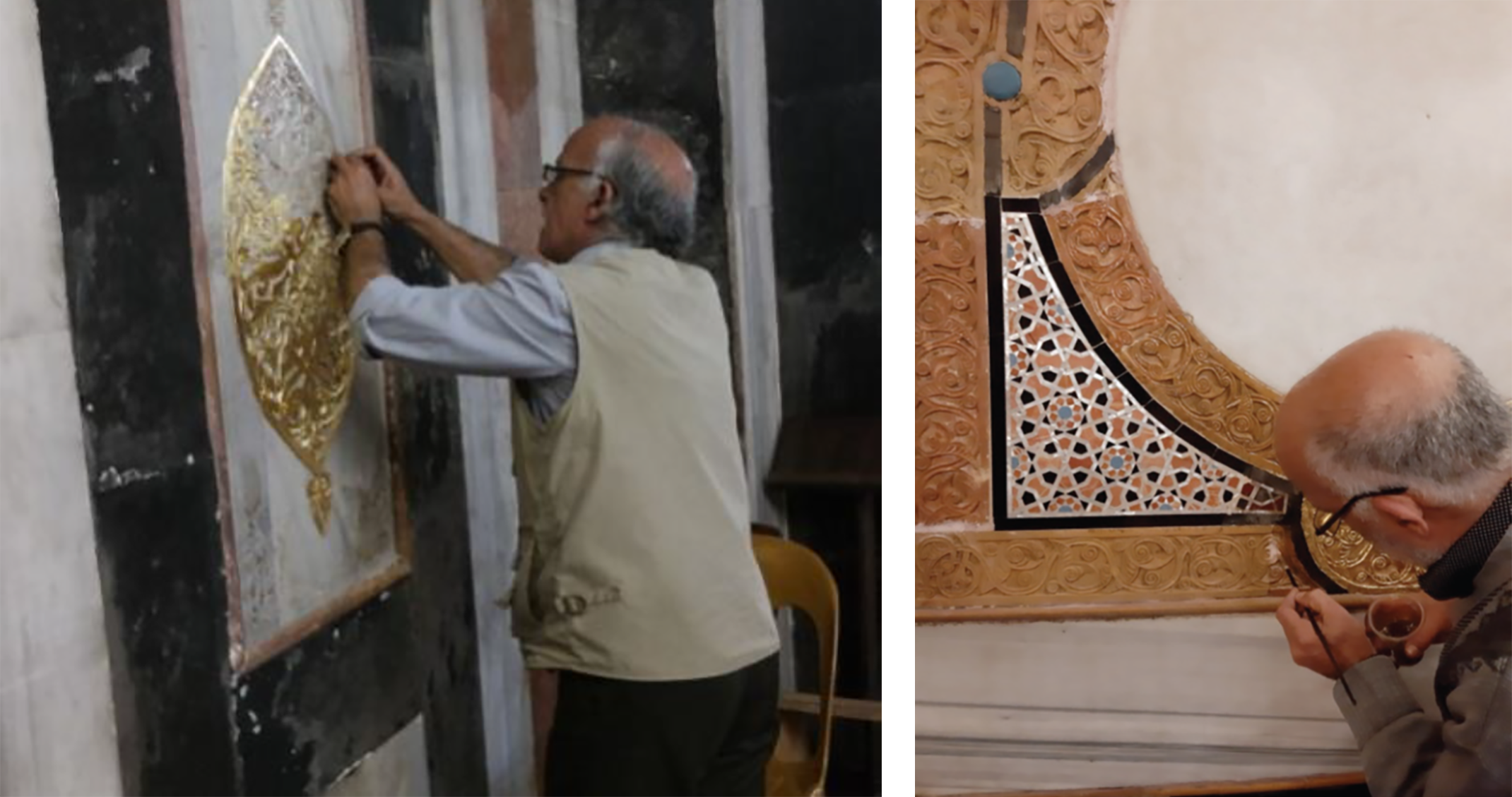
During that time as a volunteer, I surveyed some of the most prominent architectural sites in Hebron, including Al-Haram, documenting its urban context, architectural history, and details. From where I stood in Al-Ishaqeyyah Mosque, inside Al-Haram, I could see the remnants of the bullet holes that mark the wounds of the massacre. My photograph of July 17, 2019 commemorated 25 years, 4 months, and 23 days since the day Goldstein invaded the mosque. It presents two intentional acts. The scar from the bullet hole on the left is one of violence and destruction. On the right, its counter is an act of rehabilitation and care by the HRC.
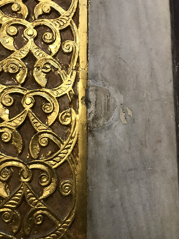
Next to one of the patched bullet holes is an ornamental detail that the HRC meticulously regilded. Nuha, the architect responsible for evaluating the work, and Khaled, the supervising technician responsible for the renovations, discussed the regilding process with me, wondering if the color matched the original intentions. The HRC had extensively researched the regilding process to maintain the site’s authenticity and to comply with heritage conservation best practices. Standing beside this patchwork, we discussed the challenging circumstances imposed by IOF restrictions and their impact on the maintenance work.
The IOF occupation exerts control over every aspect of this rehabilitation, with the authority to halt, delay, or suspend activities at will. The technicians and workers whom the IOF permits to operate in the mosque are subjected to comprehensive and recurrent security vetting. If permitted to work, they are frequently denied access to the mosque and suspended from their duties. These interruptions draw out the temporality of slow work. They delay restoration processes while also jeopardizing completed interventions, which require ongoing monitoring and tending.
The IOF also controls the entry of construction materials into the mosque. Supplies are all subjected to rigorous security inspections. There have been incidents when tools necessary for the preservation work were counted and vetted at checkpoints each day, and some were prohibited altogether.17 The HRC’s technicians responded to these severe restrictions with persistence and patience, continuing their daily projects even when tools were missing. Over the past twenty-nine years, the technicians have attended multiple workshops to learn about the gilding process, collaborating with artisans across Palestine and experts from Italy to acquire the techniques for preserving the mosque. Overall, the regilding of Al-Haram took two years to complete.18 Today, the regilded ornamental screen illuminates the patched bullet hole. Here, the slow and patient act of studying the regilding process, the careful and laborious work of regilding, and the collaborative efforts of Palestinians and international experts are not mere heritage preservation practices. These are tactical acts that resist the intensifying violence, the segregation of communities, and the elimination of Palestinian presence. This attentive labor resists the speed of dromoelimination by refusing to allow the abrupt violence of the Hebron massacre—which haunts Palestinians to this day—dictate history.19
Attentiveness becomes counter-temporal. Slowness is not to negate violence but to outlast it, to affirm life in spite of the Zionist insistence on Palestinian death, and to create continuity in the face of rupture. The gilded screen beside the bullet hole materializes this refusal. The wound is neither forgotten nor hidden; it is tended to and countered by continuous acts of care. It is laborious, emotional, and profoundly political work.20 To restore is to affirm reverence in the face of desecration.21
The Rubbing on the Map
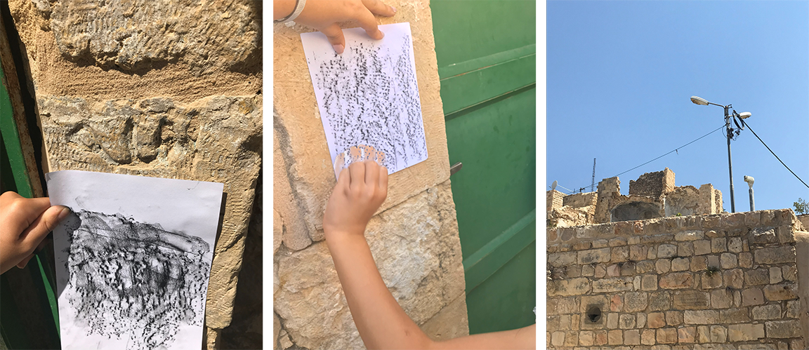
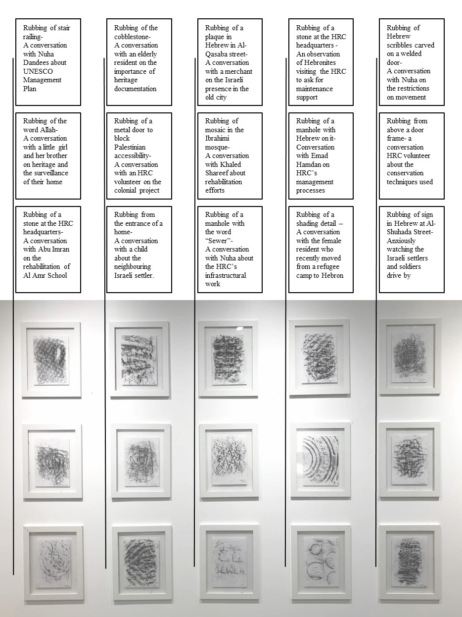
Throughout my volunteer time, I felt compelled to document these architectural details, urban surfaces, and textures through charcoal frottage rubbings as a way to ground Palestinian presence in tactile truth.22 Rubbings are intimate and slow acts—the charcoal dust on the fingers, the imprint on the paper, the pressure on the wall. The rubbings were also a method into the city and the community. As I knelt on the floor, residents showed curiosity in what I, a Palestinian woman, was doing in this unusual public practice. In one incident, during my field survey visits with the HRC, we came to a house near Al-Haram, an area accessible to Palestinians only on foot. As we surveyed the home’s historical elements and structural condition, I took a few rubbings of the details. The word “Allah” was inscribed on a door’s stone frame. I began to place the paper on it, only to be interrupted by a girl from the family, no more than ten years old, who asked to make the rubbing.
Fascinated by the practice, she then asked to create another and led me around the house to find several potential details. This kindled a sense of safety and familiarity between us. A few minutes later, her brother joined the conversation, inviting me to go to the roof to see Al-Haram from there. This was particularly meaningful; since my experience in Al-Haram was limited to the Palestinian section only, this was my first view of the whole complex. On the roof, the boy recounted the many times IOF soldiers were stationed there to surveil Al-Haram. He then pointed to the surveillance camera mounted by the IOF on their roof. As soon as he pointed it out, it rotated, staring back at us.
These are the intimate details that a map cannot tell. In another incident, I took a rubbing of a metal door near Al-Shuhada Street that the IOF had welded shut. In an aerial image, the metal door is seen as a single line. The speed of the welding disappears. The violence of the etchings by Israeli settlers is erased. The rubbing, in its grounded slowness, brought them into resolution. It marked the restriction on access placed on Palestinians and the everyday violence by settlers. Throughout this practice, the rubbings became indicators of encounter—a register of oral histories, memories, and acts of witnessing.
From the small, banal interactions with architectural details to the historical and symbolic meanings of others, the rubbings are markers of a site I could not fully access or see. In Palestine, under the gaze of the Israeli occupation, I am treated as any Palestinian citizen and restricted from accessing parts of the old city (including Al-Shuhada Street). My orientation in the city is drastically circumscribed, constrained, and reduced. To learn more about Hebron and situate myself, I turn to Google Maps, only to find that my view—of both the site and my sight—is also restricted there.
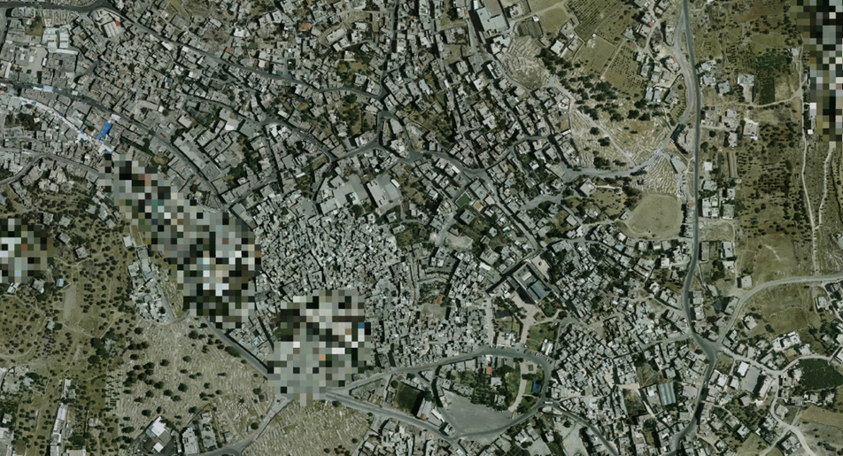
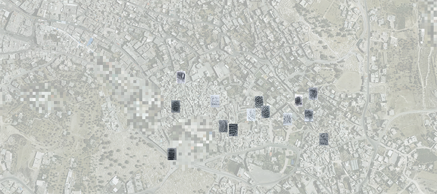
In 1996, the U.S. Congress passed the Kyl-Bingaman Amendment (KBA), which prohibits American companies from selling satellite images of the Israeli state, the West Bank, and Gaza with resolutions sharper than two meters per pixel.23 While this limitation was only a constraint placed on American retailers, some of the most extensive map providers in the global market, such as Maxar and Planet, as well as online open-access maps like Google and Bing, are American.24 This, in turn, has led to comprehensive censorship of satellite maps of the region. The consequences are profound. Publicly available satellite images of Hebron are blurred, their streets and buildings merging into indistinct volumes. The opacity of the map serves, ultimately, to erase the city’s Palestinian inhabitants and conceal Israeli colonial infrastructure activities. The Hebronites disappear, and consequently, their very existence, history, and presence cannot be recorded through digital mapping.
In June 2020, following years of pressure from academics and civil society activists, the KBA was amended to permit the use of higher-resolution imagery.25 While activists tracking Israeli settlements welcomed the change as a way to better see what’s on the ground, Israeli officials deem the clarity of images a security risk.26 The images on Google Maps continue to fluctuate between clarity and blurriness, depending on shifting political agendas and pressures. As of August 2025, many satellite images have been unblurred.
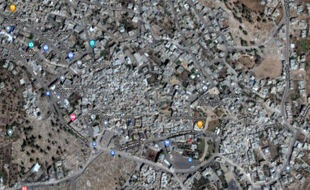
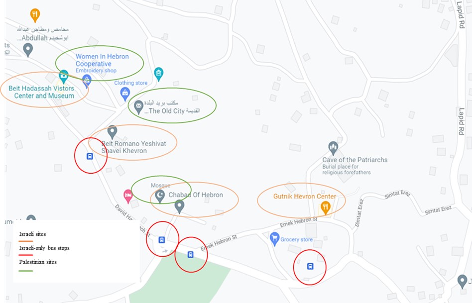
The erasure extends beyond resolution. It is further amplified by manufacturing alternative realities within the blur. When looking at a Google Maps image of the old city of Hebron, you are fed an Israeli narrative of the city with limited Palestinian presence. Google’s orienting landmarks are preestablished, pinned locations of primarily Israeli tourist sites (marked in orange). These instances of cartographic hasbara reproduce an Israeli narrative of Hebron’s past and present through linked websites that frame Hebron as a terror-ridden area, full of conflict and danger. Al-Shuhada Street, the original main artery of the old city, once bustling with noise, shops, textiles, and people, and the original site of HRC headquarters, is relabeled as David HaMelech Street.27 The historian Patrick Wolfe frames these patterns of erasure and reorientation in settler colonial contexts as a destroy in order to replace paradigm.28 Today, as I saw and was not permitted to see, the street is now a ghost town that is inaccessible to Palestinians. The bus stops on the street (marked in red) are inaccessible to Palestinians. The buildings in the street are in dire need of rehabilitation, and the courtyards are filled with waste. Now, the street is where Israeli settlers walk and drive through in cars with identifying yellow license plates, some of them armed.29
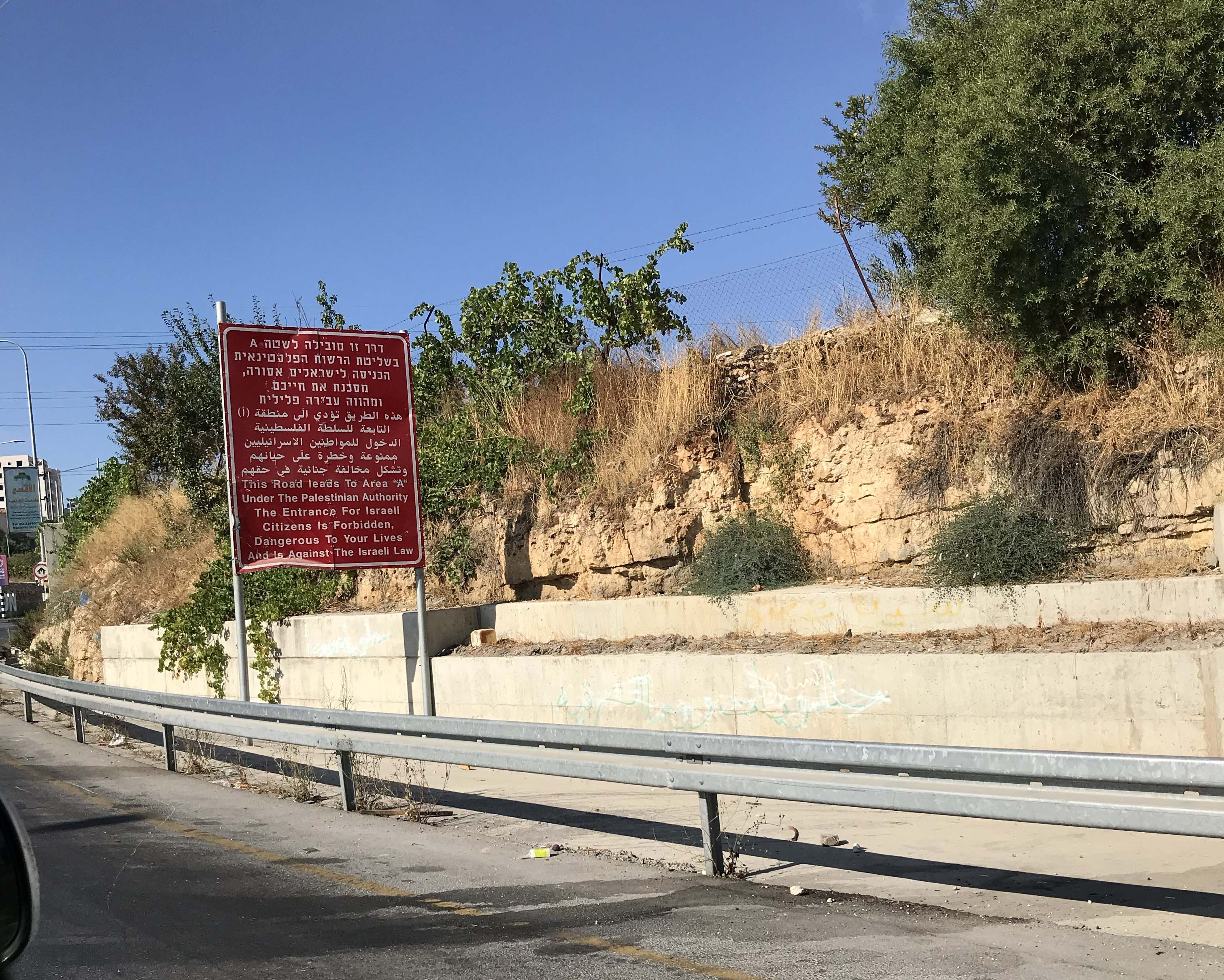
Historically, blank spaces on maps have consistently alluded to the unknown, the Other, the uncharted, the unsurveyed, and the perilous wild. From medieval mapping to the present, hic sunt dracones, here be dragons. These locations pinned on the Google map implicitly tell us what is deemed safe, known, and tangible. As you drive in the West Bank, you are constantly reminded of a colonial narrative of the barbaric, terrorist Other. Signs in red dot the landscape. As you enter Area A, which is under the control of the Palestinian Authority,30 you are reminded that “the entrance for Israeli citizens is forbidden, dangerous to your lives, and is against the Israeli law.”
Looking at commercially available aerial maps, we see and unsee. In 2019, I acquired a high-resolution satellite image from the HRC, where details of the old city are generally clearly presented; however, some locations remain pixelated and indistinct. According to a GIS expert from another Palestinian organization (who has asked to remain anonymous), Palestinians are only allowed to take aerial photographs of the West Bank after acquiring a permit from the Israeli state, which is rarely given. Most Palestinian aerial maps that Palestinian organizations use are, therefore, bought from Israeli private imaging companies that only sell images that have been censored wherever an Israeli “security concern” may exist, such as Israeli occupation military posts and Israeli settlements in Hebron.31 The pixelated fragment is yet another example of the occupation’s attempts to obscure and eliminate. The pixel, generated by a single click on a computer, erases thousands of years of history, heritage buildings, families, and kinships.
As a counter to these blurred maps and pixelated aerial images, my rubbings marked the material presence of the built environment. They evolved into a practice of slowness, attention, and community building. Each rubbing was a steady building up of resolution that required time and labor: kneeling on uneven stone, pressing paper against a wall, moving charcoal across the surface in deliberate strokes. The process was repetitive, meditative, almost ritualistic. Rubbings are a medium of imprecision—capturing essences and gestures, in contradistinction to aerial maps and cartographic drawings. Yet, they are a means of conveying what the artist Julie Mehretu termed a “psycho-geography of space.”32 The historian Sarah Lewis builds this term to define its actions as “delimited territories that show the agency born of multiple identifications and itinerancy.”33 The rubbings are spatial gestures, narratives, and histories, stitched together against the irresolution of epistemic violence. They countered the Israeli erasure of Palestinian geographies. They refused to let Palestinian presence dissolve into pixels. Unlike the speed of a computer, which blurs and pixelizes to occupy instantly, rubbings demand a grounded contact and connection with material, with the histories embedded in it, and with the conversations they opened as residents stopped to watch.
These rubbings were representations of the ground I stood on, a ground I could not see on aerial maps. As a continuation of the slow process of rubbing, and as a representation of the material connection that comes from the rubbings, I geolocated each place I documented on the blurred aerial map. These overlaid rubbings unblurred censored and inaccessible spaces. They thickened abstraction with texture, encounter, and narrative. They asserted community through connection: each rubbing a conversation, each conversation a countermap. Patience and slowness here worked not only as a research method but also as a political act—resisting erasure by insisting on presence, resolving what was obscured through embodied time.
The History in the Museum
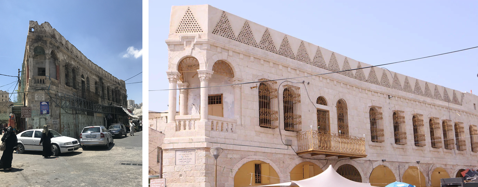
If the HRC’s gilded screen represents slowness and attentive consideration, and the rubbings represent embodied engagement as a method, the Old Hebron Museum exemplifies curation as refusal of colonial rupture. The museum is situated in a prominent building at the entrance to the old city. Originally a residential building built during the late Ottoman period and later expanded under the British Mandate, it documents the evolution of Palestinian architectural identity through different waves of occupation. From 1943 to 1963, it served as the Palestine Hotel,34 a symbol of Hebron’s early tourism and merchant economy.35 It was later leased as a shoe factory before closing during the Second Intifada in 2000. Eighteen years after this closure, a partnership was formed between UNESCO’s Ramallah office and the HRC to rehabilitate the building. Funding cycles, occupation restrictions, and technical challenges delayed progress. Yet, after three years of deliberate effort, the museum opened its doors. Its very existence is a refusal to be occupied and for its history to be erased.
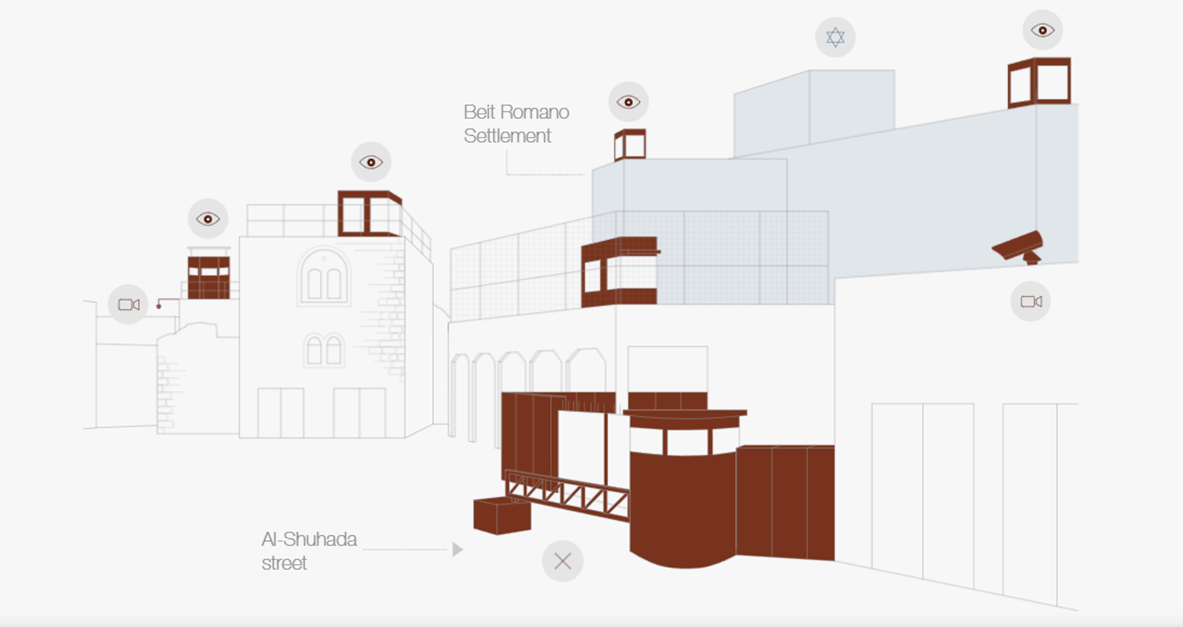
The building is located within Bab Al-Baladieh (Municipality Gate) Square, adjacent to the former municipal building. The square has historically been used as an important connector between Al-Shuhada Street and Al-Qasabah Street.36 Since Al-Shuhada Street has been off-limits to Palestinian residents, the area is now completely under the occupation’s surveillance and control. In the 3,000 square meters of Bab Al-Baladieh Square, there are six watchtowers (some located atop Palestinian homes), a metal gate that opens only for settlers, and several surveillance cameras, all managed by the IOF.
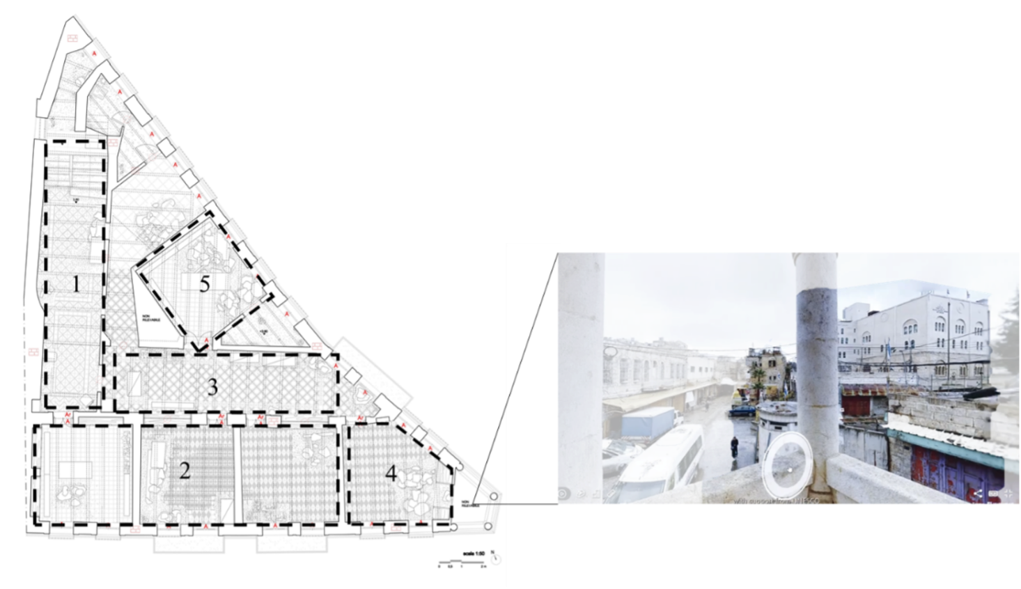
Located on the second floor of the building, the museum is organized into five spaces that trace Hebron’s history, architecture, and cultural heritage.37 Together, they present the city’s historical timeline, the Ibrahimi Mosque, HRC’s rehabilitation efforts, the political realities of occupation, and traditional crafts through a collection of artifacts. Most noteworthy is the fourth room, which features the only balcony in the building. As visitors enter the room, they encounter photographs, maps, and texts that illustrate the Israeli colonial project in the old city. Looking out from the balcony, visitors are confronted with this colonial reality in its material, tangible form, all obstruction or abstraction removed. The balcony offers a view of the Beit Romano settlement, which hides behind a barbed wire wall. The view exposes sections of the pixelated aerial map, framing an elevated view of the illegal settlement. This view collapses the distance between narrative and lived reality, insisting on material grounding. Jack Persekian, who originally curated the museum, notes:
In this place, the Israeli occupation and the aggression of its settler community are exposed in their ugliest form, flagrantly visible right in front of the museum building in the Shallala area… In this environment, the Old Hebron Museum stands as a beacon of knowledge and information for anyone trying to understand the history and context of this atypical city that is marred by in-your-face apartheid.38
The museum’s collection grounds visitors in another significant reality—the extensive history and heritage of the land. In multiple rooms, visitors are confronted with a layering of histories, including an oil lamp dating back to the Bronze Age, a Roman glass juglet, an Ottoman seal stamp, and a coin minted during the British Mandate. These objects, while minimal, counter the Zionist colonial archaeological policies that were implemented post-1948 as ideological instruments to claim the land while suppressing Palestinian presence.39 The historian Nazmi Al-Ju’beh notes that there was “an official yet ‘undeclared’ Israeli policy to dominate archaeological activities and discourage the development of local expertise.”40 Palestinians’ access to archaeological sites became restricted. Israeli excavations and looted artifacts aimed to support a Jewish-only national narrative. These archaeological excavations not only breach international laws and academic conventions, they also deprive Palestinians of the ability to investigate their own history.41
The Old Hebron Museum’s curatorial approach aims to connect and suture historical breakage, providing a vantage point for both the city’s many histories and its segregated present. The artifacts on exhibit aim to present a Palestinian reality that extends beyond a single narrative. The temporary exhibitions showcase contemporary art and still-practiced historical craft traditions, including glassblowing, ceramics, and tatreez embroidery, to extend the land’s heritage beyond the archaeological and historical, toward a much more expansive world of social, cultural, material, and economic practices. Through this outward-reaching, grounded temporality, Palestinian heritage and presence endure, insisting on visibility and continuity despite colonial attempts to rupture and erase them.
A Temporal and Spatial Resistance
Sumud—steadfastness—is engraved in the Palestinian struggle. Today, it encompasses both quiet everyday acts and deliberate political action.42 At its core, sumud is a refusal—a counter to the Zionist strategies of erasure and elimination. In her analysis of Palestinian mobility, Julie Peteet defines sumud as “staying put and getting on with life, registering a refusal to move in [the] face of continuing repression and dispossession…Its temporality is embedded in waiting, perseverance, and patience.”43 Continuity of presence is a practice of sumud. To be present amid the acceleration of colonial violence is to be patient; not in resignation but in resistance. This patience rejects the disorienting speed of attacks, restrictions, displacements, and blockades to cultivate a slower, more attentive, and embodied tempo of life.
Slowness is spatial. The speed of colonial violence disorients—it fractures perception, unsettles the ground beneath one’s feet, and reshapes how space is understood and inhabited. Against this dislocation, slowness restores orientation through grounded awareness. Slowness means knowing one’s surroundings intimately, seeing what has been obscured, and reconnecting what has been fragmented. In a colonial project that erases and removes, slowness means grounding. The restoration of Al-Haram, the tactile practice of charcoal rubbings, and the curatorial vantage point of the Old Hebron Museum each materialize this commitment to remain, to remember, and to reconstitute what colonial violence seeks to remove. Against the speed of abstraction and removal, sumud reclaims both time and ground, insisting on continuity, attention, and the right to remain and return.
-
Patrick Wolfe, “Settler Colonialism and the Elimination of the Native,” Journal of Genocide Research 8, no. 4 (2006): 387–409; Rabea Eghbariah, “The Ongoing Nakba: Toward a Legal Framework for Palestine,” N.Y.U. Review of Law & Social Change 48 (2023), link; Omar Jabary Salamanca, Mezna Qato, Kareem Rabie, and Sobhi Samour, “Past Is Present: Settler Colonialism in Palestine,” Settler Colonial Studies 2, no. 1 (2012): 1–8. ↩
-
Wassim Ghantous and Mikko Joronen, “Dromoelimination: Accelerating Settler Colonialism in Palestine,” Environment and Planning D: Society and Space 40, no. 3 (April 2022): 397. ↩
-
Middle East Monitor, “Israel Sets Up AI-Controlled Machine Gun in Occupied Hebron,” September 27, 2022, link. ↩
-
Breaking the Silence / שוברים שתיקה, “To Create the Sense of Being Chased,” YouTube, uploaded September 13, 2011, link. ↩
-
Today, the body of Baruch Goldstein is memorialized at Meir Kahane Park in Kiryat Arba, an Israeli settlement near the old city of Hebron. His grave has become a place of pilgrimage for Israeli settler extremists. A plaque near his grave is inscribed with the following: “He gave his life for the people of Israel, its Torah and the land of Israel.” In 1999, the Israeli state ordered the removal of the shrine at Goldstein’s grave. While the shrine was removed, the tomb and the plaque were left intact, along with the inscription calling Goldstein “holy.” See Lee Hochstader, “Israeli Troops Dismantle Shrine to Extremist Who Killed Muslims,” Washington Post, December 30, 1999, link. ↩
-
For more on how the Israeli state aids the settlers, see B’Tselem, “Playing the Security Card: Israeli Policy in Hebron as a Means to Effect Forcible Transfer of Local Palestinians” (September 2019), 20–21, link. ↩
-
Ofir Feuerstein, “Ghost Town: Israel’s Separation Policy and Forced Eviction of Palestinians from the Center of Hebron,” B’Tselem and the Association for Civil Rights in Israel (May 2007), 9. ↩
-
For example, in 2014, Al-Rajbi house was occupied by settlers who renamed the area Beit Hashalom. ↩
-
For example, see the practices of the settlers in Susya, Khirbat Zanuta, and Masafer Yatta; Wassim Ghantous and Mikko Joronen, “Dromoelimination: Accelerating Settler Colonialism in Palestine,” in The Other Mass Displacement: While Eyes Are on Gaza, Settlers Advance on West Bank Herders, United Nations Office for the Coordination of Humanitarian Affairs (OCHA), November 1, 2023, link; No Other Land, directed by Yuval Abraham, Basel Adra, Hamdan Ballal, and Rachel Szor (Antipode Films AS, 2024), documentary. ↩
-
“Hebron Massacre,” Interactive Encyclopedia of the Palestine Question, link. ↩
-
Nazmi Al-Jubeh, ed., Old Hebron: The Charm of a Historical City and Architecture (Hebron: Hebron Rehabilitation Committee, 2009), 25. ↩
-
Norwegian Refugee Council (NRC), “Expert Opinion on the Effects of the Israeli Military Rule and Settlement Expansion on the Cultural Heritage in the City of Hebron,” link. ↩
-
B’Tselem, “Playing the Security Card.” ↩
-
B’Tselem, “Playing the Security Card,” 25. ↩
-
For more about the division of the Ibrahimi Mosque, see “Ibrahimi Mosque,” Hebron Apartheid (2018), link. ↩
-
H1, where most Hebronites reside, encompasses approximately 80 percent of the city. In this area, the Palestinian Authority (PA) is responsible for managing security and civilian affairs. In H2, which includes the old city, security control remained under the jurisdiction of the Israeli state, while civilian matters fell within the purview of the PA. See “The Hebron Protocol,” Journal of Palestine Studies 26, no. 3 (1997): 131–45. ↩
-
See Hebron Rehabilitation Committee, “2021 Annual Report,” 22, link. ↩
-
Khaled in conversation with the author (Palestine, July 20, 2019). ↩
-
Nigel Wilson, “Remembering the Ibrahimi Mosque Massacre,” Al Jazeera, February 26, 2016, link. ↩
-
Menna Agha, “Emotional Capital and Other Ontologies of the Architect,” Architectural Histories 8, no. 1 (2020): 1–13. ↩
-
Mohamad Nahleh, “Purging a Wretched Empire,” Avery Review 71 (April 2025), link. ↩
-
Also see the work of Michael Rakowitz, The flesh is yours, the bones are ours (frottages) (2015). ↩
-
“National Defense Authorization Act for Fiscal Year 1997,” <link. Linda Quiquivix, “Art of War, Art of Resistance: Palestinian Counter-Cartography on Google Earth,” Annals of the Association of American Geographers 104, no. 3 (2014): 444–459. The law was amended in 2020 to permit higher-resolution images. ↩
-
Looking at the complicity of the aerial maps and their providers in supporting state power, Taylor Miller describes these maps as genocide’s currency. See Taylor Miller, “Maps as Genocide’s Currency,” Corruption Tracker, February 3, 2025, link. ↩
-
National Oceanic and Atmospheric Administration, “Notice of Findings Regarding Commercial Availability of Non-U.S. Satellite Imagery with Respect to Israel,” Federal Register, July 21, 2020, link. ↩
-
Dan Williams, “Israel Feels Exposed as U.S. Drops Satellite-Imaging Cap,” Reuters, July 6, 2020, link. ↩
-
David HaMelech is the Hebrew name of King David, a biblical figure in the Old Testament books 1 Samuel, 2 Samuel, 1 Chronicles, and 2 Chronicles. According to the biblical narrative, David was one of the greatest kings of Judea who, as a young boy, defeated the Philistine giant Goliath with a slingshot and a stone. ↩
-
Illustrating how settler colonialism eliminates the natives, Wolfe highlights the Zionist strategy to destroy in order to replace, where the Zionists have renamed cities, uprooted ancient trees and landscapes, and demolished existing buildings for the sake of creating an Israeli state with its particular narratives. See Wolfe, “Settler Colonialism and the Elimination of the Native,” 388. ↩
-
For example, see the image here: ISM Palestine, “Settlers Taking a Walk on Shuhada Street,” Flickr, photograph by Stella, taken November 6, 2010, uploaded November 17, 2010, link. ↩
-
The Oslo Accords in 1995 stipulated the division of the West Bank into three land designations with different levels of control. Area A is under the Palestinian Authority (PA)’s civilian and security control. Area B is under the PA’s public order, but the Israeli state maintains an overriding responsibility for control and security. In Area C, the Israeli state retained full control of security and civil issues. See “The Peace Process,” Journal of Palestine Studies 25, no. 2 (1996): 123–40. ↩
-
GIS expert (kept anonymous) in conversation with the author (Ottawa and Palestine, October 20, 2021). ↩
-
Sarah E. Lewis, “UNHOMED GEOGRAPHIES: The Paintings of Julie Mehretu,” Callaloo 33, no. 1 (2010): 220. ↩
-
Lewis, “UNHOMED GEOGRAPHIES.” ↩
-
Wisam Shaded, “Palestine Hotel in the Old City of Hebron, Between Modernity and Traditional Dwelling Architecture During the 19th–20th Century,” ARCHive-SR 7, no. 3 (2023): 16–33. ↩
-
The Chamber of Commerce opened in one of the rooms of the hotel in 1953 to enable the merchants who stayed in the hotel to obtain a permit. ↩
-
Al-Qasabah Street is the other main commercial artery in Hebron. ↩
-
Hebron Rehabilitation Committee, 2022, “متحف البلدة القديمة,” link. ↩
-
Jack Persekian, “Old Hebron Museum,” This Week in Palestine, December 2021, link. ↩
-
For more on the archeological warfare in Palestine, see Abu Nadia Abu El-Haj, Facts on the Ground: Archaeological Practice and Territorial Self-Fashioning in Israeli Society (Chicago: University of Chicago Press, 2001). ↩
-
Nazmi Al-Ju’beh, “Cultural Heritage in Palestine: Contested and Neglected Heritage,” RIWAQ, 2008, link. ↩
-
Ahmed A. Rjoob, “The Impact of Israeli Occupation on the Conservation of Cultural Heritage Sites in the Occupied Palestinian Territories: The Case of ‘Salvage Excavations,’ ” Conservation and Management of Archaeological Sites 11, nos. 3–4 (2009): 214–35. ↩
-
For more on sumud as a Palestinian practice, see Runa Johannessen, “Sumud: Steadfastness as Everyday Resistance,” Interactive Encyclopedia of the Palestine Question, link. ↩
-
Julie Peteet, Space and Mobility in Palestine (Bloomington: Indiana University Press, 2017), 171. ↩
Rana Abughannam is a Palestinian architect, scholar, and educator with an interest in the politics that govern urbanism and built heritage. Her research focuses on paradigms of counter-colonization exemplified in Indigenous, bottom-up, and constant practices of resistance against ongoing colonial projects. She is an Assistant Professor at the School of Architecture and Landscape Architecture at the University of British Columbia.